IMAGES TAKEN NEAR TO
Cwrt Yr Afon, ABERDARE, CF44 8PQ
Introduction
This page details the photographs taken nearby to Cwrt Yr Afon, CF44 8PQ by members of the Geograph project.
The Geograph project started in 2005 with the aim of publishing, organising and preserving representative images for every square kilometre of Great Britain, Ireland and the Isle of Man.

There are currently over 7.5m images from over14,400 individuals and you can help contribute to the project by visiting https://www.geograph.org.uk
Image Map
Images are licensed for reuse under creativecommons.org/licenses/by-sa/2.0
Notes
- Clicking on the map will re-center to the selected point.
- The higher the marker number, the further away the image location is from the centre of the postcode.
Image Listing (31 Images Found)
Images are licensed for reuse under creativecommons.org/licenses/by-sa/2.0
Image
Details
Distance
1
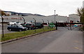
Entrance to the Prysmian factory in Trecynon
From the B4276. Their website describes Prysmian as "World leader in the industry of high-technology cables and systems for energy and telecommunications". In the UK Prysmian manufactures energy cables from low voltage to extremely high voltage for land applications.
Image: © Jaggery
Taken: 3 May 2014
0.03 miles
2
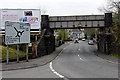
Under a railway bridge towards Trecynon
The B4276 from Llwyncoed passes under the bridge carrying a freight-only railway. Headroom shown is 15' 9".
Image: © Jaggery
Taken: 3 May 2014
0.03 miles
3
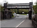
Railway bridge in Llwydcoed
The B4276 passes under the bridge carrying a freight-only railway between Aberdare and Hirwaun. Headroom shown is 15' 9"
Image: © Jaggery
Taken: 3 May 2014
0.03 miles
4
Welcome to Llwydcoed
The B4276 from Trecynon passes the Welcome sign at the southern edge of Llwydcoed,
a small village near Aberdare.
Image: © Jaggery
Taken: 3 May 2014
0.03 miles
5
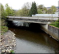
River between two bridges near Llwydcoed
Viewed from the B4276 looking along the Afon Cynon towards the A4059 bridge.
Image: © Jaggery
Taken: 3 May 2014
0.03 miles
6
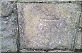
Ordnance Survey Cut Mark
This OS cut mark can be found on the NW parapet of the bridge. It marks a point 140.095m above mean sea level.
Image: © Adrian Dust
Taken: 7 Dec 2020
0.04 miles
7
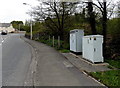
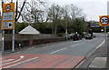
Roadside cabinets in Llwydcoed
Labels on the cabinets alongside the B4276 show T-MOBILE (UK).
Image: © Jaggery
Taken: 3 May 2014
0.06 miles
8
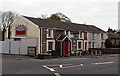
Bridgend Inn, Trecynon
On the corner of Harriet Street and the A4059.
Image: © Jaggery
Taken: 3 May 2014
0.06 miles
9
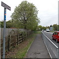
Cynon Trail, Trecynon
For about 20 metres, the route of the Cynon Trail (and National Cycle Network route 47) is alongside the A4059, before branching off to the left to follow a more typical quieter route.
Image: © Jaggery
Taken: 3 May 2014
0.08 miles
10
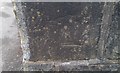
Ordnance Survey Cut Mark
This inverted OS cut mark can be found on the wall of No47 Harriet Street. It marks a point 152.348m above mean sea level.
Image: © Adrian Dust
Taken: 1 Jun 2017
0.08 miles