IMAGES TAKEN NEAR TO
David Street, ABERDARE, CF44 8NE
Introduction
This page details the photographs taken nearby to David Street, CF44 8NE by members of the Geograph project.
The Geograph project started in 2005 with the aim of publishing, organising and preserving representative images for every square kilometre of Great Britain, Ireland and the Isle of Man.

There are currently over 7.5m images from over14,400 individuals and you can help contribute to the project by visiting https://www.geograph.org.uk
Image Map
Images are licensed for reuse under creativecommons.org/licenses/by-sa/2.0
Notes
- Clicking on the map will re-center to the selected point.
- The higher the marker number, the further away the image location is from the centre of the postcode.
Image Listing (74 Images Found)
Images are licensed for reuse under creativecommons.org/licenses/by-sa/2.0
Image
Details
Distance
1
Margaret Street, Trecynon
Looking NW from the corner of Mount Pleasant Street and Alma Street.
Image: © Jaggery
Taken: 3 May 2014
0.01 miles
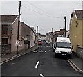
2

David Street, Trecynon
Viewed from the Hirwaun Road; New Hope Mission Church is the pebbledash building on the left corner.
Image: © Jonathan Billinger
Taken: 22 Aug 2013
0.02 miles
3
Frederick Street, Trecynon
Viewed across Hirwaun Road.
Image: © Jaggery
Taken: 3 May 2014
0.02 miles
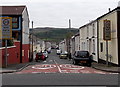
4
Hope Church, Trecynon
On the corner of Hirwaun Road and David Street, opposite Aberdare Park.
The building was formerly the Apostolic Church, Trecynon.
Image: © Jaggery
Taken: 3 May 2014
0.02 miles
5
Ordnance Survey Pivot
This heavily painted OS pivot can be found on the window sill of No18 Hirwaun Road. It marks a point 154.637m above mean sea level.
Image: © Adrian Dust
Taken: 1 Jun 2017
0.03 miles
6
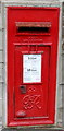
King George VI postbox, Mount Pleasant Street, Trecynon
In the wall here. http://www.geograph.org.uk/photo/3967703
Image: © Jaggery
Taken: 3 May 2014
0.03 miles
7
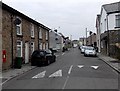
Mount Pleasant Street towards Ebenezer Street, Trecynon
There is a King George VI postbox http://www.geograph.org.uk/photo/3967712 in the wall on the left. The left turn is into David Street.
Image: © Jaggery
Taken: 3 May 2014
0.04 miles
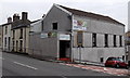
8
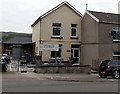
Phillips Monumental Sculptors, Trecynon
Premises in Parc Olwg, Hirwaun Road.
Image: © Jaggery
Taken: 3 May 2014
0.04 miles
9
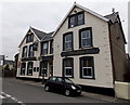
Brynhyfryd, Trecynon
Viewed across Mount Pleasant Street. This side shows the pub's Welsh name.
The far side http://www.geograph.org.uk/photo/3967534 shows its English name, Mount Pleasant (Hotel).
Image: © Jaggery
Taken: 3 May 2014
0.05 miles
10
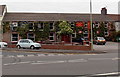
Welsh Harp Inn and Cross Inn, Trecynon
Viewed across the B4275. Cross Inn is on the left, Welsh Harp on the right.
Image: © Jaggery
Taken: 3 May 2014
0.05 miles