IMAGES TAKEN NEAR TO
Cledwyn Terrace, ABERDARE, CF44 8HW
Introduction
This page details the photographs taken nearby to Cledwyn Terrace, CF44 8HW by members of the Geograph project.
The Geograph project started in 2005 with the aim of publishing, organising and preserving representative images for every square kilometre of Great Britain, Ireland and the Isle of Man.

There are currently over 7.5m images from over14,400 individuals and you can help contribute to the project by visiting https://www.geograph.org.uk
Image Map
Images are licensed for reuse under creativecommons.org/licenses/by-sa/2.0
Notes
- Clicking on the map will re-center to the selected point.
- The higher the marker number, the further away the image location is from the centre of the postcode.
Image Listing (45 Images Found)
Images are licensed for reuse under creativecommons.org/licenses/by-sa/2.0
Image
Details
Distance
1
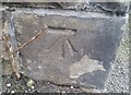
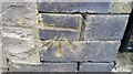
Ordnance Survey Cut Mark
This OS cut mark can be found on the wall of No15 Cemetery Road. It marks a point 165.994m above mean sea level.
Image: © Adrian Dust
Taken: 1 Jun 2017
0.04 miles
2
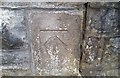
Ordnance Survey Cut Mark
This OS cut mark can be found on the wall post of Aberdare Park. It marks a point 162.507m above mean sea level.
Image: © Adrian Dust
Taken: 1 Jun 2017
0.09 miles
3
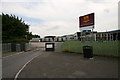
Aberdare Boys Comprehensive School
Aberdare Boys Comprehensive School on Cwmdare Road, Trecynon.
Image: © Darren W Rees
Taken: 24 Jul 2008
0.14 miles
4
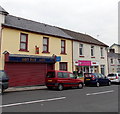
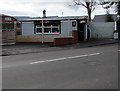
Hot Pot Cafe, Trecynon
There was a For Sale board on the wall of the shuttered premises on the left in early May 2014.
The letter C is missing from the cafe's nameboard.
Bouquets and Baskets (flowers for all occasions) is next door.
Image: © Jaggery
Taken: 3 May 2014
0.16 miles
5

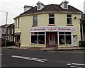
Sheppards Pharmacy in Trecynon
The Mill Street pharmacy is opposite Margaret Street.
Image: © Jaggery
Taken: 3 May 2014
0.16 miles
6
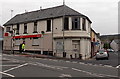
Vacant corner shop in Trecynon
The shop on the corner of Cemetery Road and Mill Street has been vacant for several years.
The Ladbrokes betting shop is at 110 Cemetery Road.
Image: © Jaggery
Taken: 3 May 2014
0.16 miles
7
Ordnance Survey Cut Mark
This OS cut mark can be found at the entrance to the Electric Sub-Station on Hirwaun Road. It marks a point 158.581m above mean sea level.
Image: © Adrian Dust
Taken: 1 Jun 2017
0.16 miles
8
Mill Street Carpets, Trecynon
Carpet shop at 76 Mill Street, near the corner of Hirwaun Road.
Image: © Jaggery
Taken: 3 May 2014
0.17 miles
9
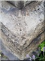
Ordnance Survey Pivot
This OS pivot can be found on the west angle of Bryn Seion Chapel. It marks a point 156.088m above mean sea level.
Image: © Adrian Dust
Taken: 1 Jun 2017
0.17 miles
10
Burger Express, 46 Cemetery Road, Trecynon, Aberdare
Viewed across the B4275 Cemetery Road in February 2019.
The name on the premises in a June 2011 Google Street View was Baguette Express.
Image: © Jaggery
Taken: 11 Feb 2019
0.17 miles