1
Ordnance Survey Cut Mark
This OS cut mark can be found on the wall post of Aberdare Park. It marks a point 162.507m above mean sea level.
Image: © Adrian Dust
Taken: 1 Jun 2017
0.04 miles
2
Ordnance Survey Cut Mark
This OS cut mark can be found on the wall of No15 Cemetery Road. It marks a point 165.994m above mean sea level.
Image: © Adrian Dust
Taken: 1 Jun 2017
0.05 miles
3
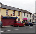
Sheppards Pharmacy in Trecynon
The Mill Street pharmacy is opposite Margaret Street.
Image: © Jaggery
Taken: 3 May 2014
0.09 miles
4
Ordnance Survey Pivot
This OS pivot can be found on the west angle of Bryn Seion Chapel. It marks a point 156.088m above mean sea level.
Image: © Adrian Dust
Taken: 1 Jun 2017
0.10 miles
5
Hot Pot Cafe, Trecynon
There was a For Sale board on the wall of the shuttered premises on the left in early May 2014.
The letter C is missing from the cafe's nameboard.
Bouquets and Baskets (flowers for all occasions) is next door.
Image: © Jaggery
Taken: 3 May 2014
0.10 miles
6
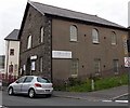
South side of Bryn Sion Baptist Chapel, Trecynon
This is the Mill Street and Margaret Street side of the chapel, erected in 1862.
Image: © Jaggery
Taken: 3 May 2014
0.10 miles
7
Vacant corner shop in Trecynon
The shop on the corner of Cemetery Road and Mill Street has been vacant for several years.
The Ladbrokes betting shop is at 110 Cemetery Road.
Image: © Jaggery
Taken: 3 May 2014
0.10 miles
8
North side of Bryn Sion Baptist Chapel, Trecynon
This is the Mill Street and Mount Pleasant Street side of the chapel, erected in 1862.
Image: © Jaggery
Taken: 3 May 2014
0.11 miles
9
Mill Street Carpets, Trecynon
Carpet shop at 76 Mill Street, near the corner of Hirwaun Road.
Image: © Jaggery
Taken: 3 May 2014
0.11 miles
10
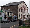
Post Office and Community Hall, Trecynon
Viewed across Mill Street. The large community hall, dating from 1902, was renovated in 2012.
Image: © Jaggery
Taken: 3 May 2014
0.11 miles


