1
Former Siloh Chapel, Trecynon, Aberdare
Viewed across Mount Pleasant Street. The years 1889 (year of construction) and 1902 (rebuilt) are inscribed on the wall of the building on the left, now a private residence, Siloh House.
Image: © Jaggery
Taken: 3 May 2014
0.02 miles
2
Mount Pleasant Street, Trecynon
Siloh Chapel, Trecynon, viewed from Hirwaun Road.
Image: © Jonathan Billinger
Taken: 22 Aug 2013
0.02 miles
3
Ordnance Survey Cut Mark
This OS cut mark can be found on No2 Broniestyn Terrace. It marks a point 142.717m above mean sea level.
Image: © Adrian Dust
Taken: 1 Jun 2017
0.03 miles
4
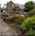
Comin School Allotments, Trecynon, Aberdare
Owned by Rhondda Cynon Taf Council, the allotment occupies a small triangular site between Hirwaun Road and Mount Pleasant Street, at the edge of Aberdare Park Primary School.
Image: © Jaggery
Taken: 3 May 2014
0.04 miles
5
Ordnance Survey Cut Mark
This OS cut mark can be found on the south angle of Comin School. It marks a point 151.608m above mean sea level.
Image: © Adrian Dust
Taken: 1 Jun 2017
0.04 miles
6
Aberdare Park Primary School, Trecynon
Viewed across the B4275 Hirwaun Road.
Image: © Jaggery
Taken: 3 May 2014
0.06 miles
7
West side of Aberdare Park Primary School, Trecynon
Viewed across Mount Pleasant Street. The school was previously Comin Junior School.
Image: © Jaggery
Taken: 3 May 2014
0.08 miles
8
Ordnance Survey Pivot
This heavily painted OS pivot can be found on the window sill No24B Hirwaun Road. It marks a point 154.137m above mean sea level.
Image: © Adrian Dust
Taken: 1 Jun 2017
0.09 miles
9
Mount Pleasant Hotel, Trecynon
Pub on the corner of Mount Pleasant Street and Alma Street. This side of the pub shows its English name. Its Welsh name, Brynhyfryd, is on the far side. http://www.geograph.org.uk/photo/3967550
Image: © Jaggery
Taken: 3 May 2014
0.11 miles
10
Phillips Monumental Sculptors, Trecynon
Premises in Parc Olwg, Hirwaun Road.
Image: © Jaggery
Taken: 3 May 2014
0.11 miles


