IMAGES TAKEN NEAR TO
North Avenue, ABERDARE, CF44 8BB
Introduction
This page details the photographs taken nearby to North Avenue, CF44 8BB by members of the Geograph project.
The Geograph project started in 2005 with the aim of publishing, organising and preserving representative images for every square kilometre of Great Britain, Ireland and the Isle of Man.

There are currently over 7.5m images from over14,400 individuals and you can help contribute to the project by visiting https://www.geograph.org.uk
Image Map
Images are licensed for reuse under creativecommons.org/licenses/by-sa/2.0
Notes
- Clicking on the map will re-center to the selected point.
- The higher the marker number, the further away the image location is from the centre of the postcode.
Image Listing (118 Images Found)
Images are licensed for reuse under creativecommons.org/licenses/by-sa/2.0
Image
Details
Distance
1
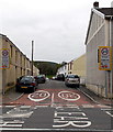
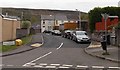
North Avenue, Gadlys, Aberdare
Viewed across Gadlys Road looking along a 20mph maximum speed zone towards Dowlais Street.
Image: © Jaggery
Taken: 3 May 2014
0.02 miles
2
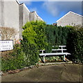
Metal bench on an Aberdare corner
On the Gadlys Road side of the corner of Neville Terrace.
Image: © Jaggery
Taken: 4 Feb 2019
0.02 miles
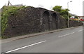
3
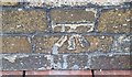
Ordnance Survey Cut Mark
This OS cut mark can be found on the north angle of the Funeral building. It marks a point 142.287m above mean sea level.
Image: © Adrian Dust
Taken: 1 Jun 2017
0.03 miles
4
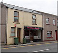
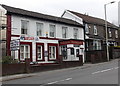
Stephen Paul unisex hair salon in Aberdare
The salon is at 77 Gadlys Road, near Lidl.
Image: © Jaggery
Taken: 3 May 2014
0.03 miles
5
East Avenue, Gadlys, Aberdare
Viewed across Gadlys Road. The name sign on the left shows that East Avenue leads to Maelgwyn Terrace, Lambert Terrace and Cooperative Cottages.
Image: © Jaggery
Taken: 3 May 2014
0.03 miles
6
Remains of a long-since demolished railway bridge, Gadlys Road, Aberdare
More than a century ago there was an industrial railway in this area. Part of its route is now the East Avenue roadway. The railway bridge over Gadlys Road at this point was demolished in 1912 after closure of the railway.
Image: © Jaggery
Taken: 3 May 2014
0.04 miles
7
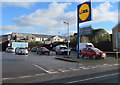
Lidl name sign and car park, Aberdare
On the east side of the B4275 Gadlys Road. In February 2019, the notice below the name sign shows that the nearby Lidl supermarket https://www.geograph.org.uk/photo/6054276 is open from 8am-10pm Mondays-Saturdays and from 10am-4pm on Sundays.
Image: © Jaggery
Taken: 4 Feb 2019
0.06 miles
8
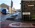
Oxford Street name signs, Aberdare
On the corner of the B4275 Gadlys Road. The larger street name sign
shows that Oxford Street leads to Dowlais Street and Gadlys Street.
Image: © Jaggery
Taken: 4 Feb 2019
0.06 miles
9
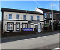
Mackworth, Aberdare
Pub at 25 Gadlys Road, formerly The Mackworth Arms.
Image: © Jaggery
Taken: 3 May 2014
0.06 miles
10
The Mackworth Arms, 25 Gadlys Road, Aberdare
Viewed across the B4275 Gadlys Road in February 2019.
The pub name was Mackworth in May 2014. https://www.geograph.org.uk/photo/3964842
Image: © Jaggery
Taken: 4 Feb 2019
0.06 miles