IMAGES TAKEN NEAR TO
Lambert Terrace, ABERDARE, CF44 8AT
Introduction
This page details the photographs taken nearby to Lambert Terrace, CF44 8AT by members of the Geograph project.
The Geograph project started in 2005 with the aim of publishing, organising and preserving representative images for every square kilometre of Great Britain, Ireland and the Isle of Man.

There are currently over 7.5m images from over14,400 individuals and you can help contribute to the project by visiting https://www.geograph.org.uk
Image Map
Images are licensed for reuse under creativecommons.org/licenses/by-sa/2.0
Notes
- Clicking on the map will re-center to the selected point.
- The higher the marker number, the further away the image location is from the centre of the postcode.
Image Listing (89 Images Found)
Images are licensed for reuse under creativecommons.org/licenses/by-sa/2.0
Image
Details
Distance
1
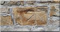
Ordnance Survey Cut Mark
This OS cut mark can be found on No17B Margan Street. It marks a point 146.347m above mean sea level.
Image: © Adrian Dust
Taken: 1 Jun 2017
0.05 miles
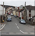
2
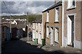
Gadlys Terrace, Aberdare
A street of terraced houses near the centre of Aberdare, typical of the towns of the South Wales valleys.
Image: © B Whitmore
Taken: 10 Oct 2009
0.06 miles
3
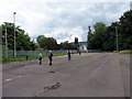
Hen faes parcio / Disused car Park
Cerddwyr yn mynd drwy hen faes parcio yn Aberdar.
Walkers going through a disused car park in Aberdare < Aberdar (trans. confluence of the oak river).
Image: © Alan Richards
Taken: 30 Jul 2016
0.06 miles
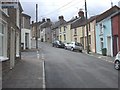
5
Morgan Street, Aberdare
Viewed from Gadlys Road.
Image: © Jaggery
Taken: 3 May 2014
0.09 miles
6
Ordnance Survey Rivet
This OS rivet can be found on the wall of No6 Gadlys Terrace. It marks a point 141.961m above mean sea level.
Image: © Adrian Dust
Taken: 1 Jun 2017
0.10 miles
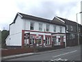
8
Gadlys Terrace, Gadlys, Aberdare
Viewed across the B4275 Gadlys Road.
Image: © Jaggery
Taken: 3 May 2014
0.10 miles
9
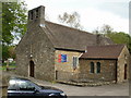
St John the Baptist Church, Aberdare
The church is the original parish church of Aberdare, located in the centre of the town adjacent to High Street and Green Street.
The exact date of its construction is unknown, but evidence points to the last quarter of the twelfth century, making the church the oldest extant building in Aberdare by some 600 years. The church seen here has not been radically altered from the original medieval building.
Image: © Jaggery
Taken: 28 Apr 2010
0.11 miles
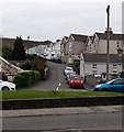
10
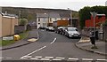
East Avenue, Gadlys, Aberdare
Viewed across Gadlys Road. The name sign on the left shows that East Avenue leads to Maelgwyn Terrace, Lambert Terrace and Cooperative Cottages.
Image: © Jaggery
Taken: 3 May 2014
0.12 miles