IMAGES TAKEN NEAR TO
Highland Place, ABERDARE, CF44 7RA
Introduction
This page details the photographs taken nearby to Highland Place, CF44 7RA by members of the Geograph project.
The Geograph project started in 2005 with the aim of publishing, organising and preserving representative images for every square kilometre of Great Britain, Ireland and the Isle of Man.

There are currently over 7.5m images from over14,400 individuals and you can help contribute to the project by visiting https://www.geograph.org.uk
Image Map
Images are licensed for reuse under creativecommons.org/licenses/by-sa/2.0
Notes
- Clicking on the map will re-center to the selected point.
- The higher the marker number, the further away the image location is from the centre of the postcode.
Image Listing (89 Images Found)
Images are licensed for reuse under creativecommons.org/licenses/by-sa/2.0
Image
Details
Distance
1
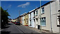
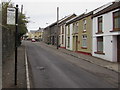
Highland Place, Aberdare
Residential street leading to Ty Fry.
Image: © Jonathan Billinger
Taken: 22 Aug 2013
0.01 miles
2
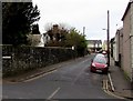
Highland Place, Aberdare
Viewed across the A4233.
Image: © Jaggery
Taken: 5 Feb 2015
0.01 miles
3
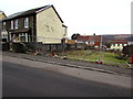
Fenced-off site on the north side of Highland Place, Aberdare
In early February 2015, little remains to indicate what used to be here.
Behind the fence are a few fragments of rubble, traffic cones and grass.
Image: © Jaggery
Taken: 5 Feb 2015
0.01 miles
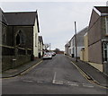
4
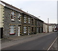
Row of houses, Highland Place, Aberdare
Viewed looking towards the A4233 Monk Street.
Image: © Jaggery
Taken: 5 Feb 2015
0.03 miles
5
Highland Place bus stop pole, Aberdare
I used "bus stop pole" instead of "bus stop" because it's unclear whether this is still a bus stop. Others I passed in Aberdare today all have yellow BUS STOP and the Welsh equivalent painted on the road surface. There is no timetable information here, only an indication that this is (was?) part of bus route 2, which means nothing to this visitor to Aberdare.
Image: © Jaggery
Taken: 5 Feb 2015
0.03 miles
6
Unity Street, Aberdare
Viewed across Monk Street. Highland Place Unitarian Church http://www.geograph.org.uk/photo/4337551 is on the left.
Image: © Jaggery
Taken: 5 Feb 2015
0.03 miles
7
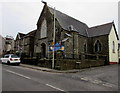
Highland Place Unitarian Church in Aberdare
The nameboard on the corner of Monk Street and Unity Street shows that the church was built in 1860, renovated in 1996.
Image: © Jaggery
Taken: 5 Feb 2015
0.04 miles
8
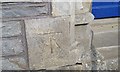
Ordnance Survey Cut Mark
This OS cut mark can be found on the front of the Unitarian Church. It marks a point 158.908m above mean sea level.
Image: © Adrian Dust
Taken: 1 Jun 2017
0.04 miles
9
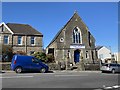
Chapel at Graig Isaf
Aberdare Unitarian Church, Aberdare.
Image: © Alan Hughes
Taken: 16 Mar 2020
0.04 miles
10
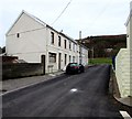
Arnott Place, Aberdare
30 metre long row of houses on the south side of Harlech Place.
Image: © Jaggery
Taken: 5 Feb 2015
0.05 miles