IMAGES TAKEN NEAR TO
Heol-y-Mynydd, ABERDARE, CF44 7PS
Introduction
This page details the photographs taken nearby to Heol-y-Mynydd, CF44 7PS by members of the Geograph project.
The Geograph project started in 2005 with the aim of publishing, organising and preserving representative images for every square kilometre of Great Britain, Ireland and the Isle of Man.

There are currently over 7.5m images from over14,400 individuals and you can help contribute to the project by visiting https://www.geograph.org.uk
Image Map
Images are licensed for reuse under creativecommons.org/licenses/by-sa/2.0
Notes
- Clicking on the map will re-center to the selected point.
- The higher the marker number, the further away the image location is from the centre of the postcode.
Image Listing (55 Images Found)
Images are licensed for reuse under creativecommons.org/licenses/by-sa/2.0
Image
Details
Distance
1
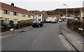
Heol-y-Mynydd, Aberdare
Viewed from the northern end of the long dead-end road.
Image: © Jaggery
Taken: 5 Feb 2015
0.03 miles
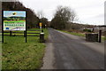
3
No through road from Aberdare to Cwmdare
The yellow notice is near the Heol-y-Mynydd entrance http://www.geograph.org.uk/photo/4341317 at the eastern edge of the Dare Valley Country Park. This is not a through route for motor vehicles, but walkers and cyclists can reach Cwmdare this way.
Below the yellow sign, a smaller sign shows a maximum £1,000 fine on conviction for dog owners who do not clean up their pet's droppings.
Image: © Jaggery
Taken: 5 Feb 2015
0.05 miles
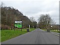
4
Eastern entrance to the Dare Valley Country Park
From Heol-y-Mynydd Aberdare into 500 acres of countryside walks and trails between Aberdare and Cwmdare.
Image: © Jaggery
Taken: 5 Feb 2015
0.05 miles
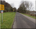
5
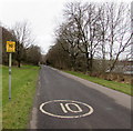
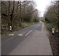
10mph speed limit through Dare Valley Country Park
This is the Aberdare (eastern) part of the road through the country park.
Image: © Jaggery
Taken: 5 Feb 2015
0.06 miles
6
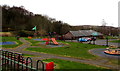
Playground at the edge of St Margaret's Roman Catholic School, Aberdare
Some of the school buildings are on the right. A fence separates the playground from the school grounds.
Image: © Jaggery
Taken: 5 Feb 2015
0.06 miles
7
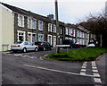
Harlech Place, Aberdare
A sign in front of Harlech Place pointing left shows ARNOTT'S PLACE though
the name sign alongside the row of houses (out of shot) http://www.geograph.org.uk/photo/4339235 shows ARNOTT PLACE.
Image: © Jaggery
Taken: 5 Feb 2015
0.07 miles
8
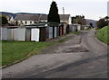
Lockup garages on the east side of Heol-y-Mynydd, Aberdare
Image: © Jaggery
Taken: 5 Feb 2015
0.08 miles
9
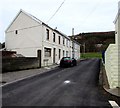
Arnott Place, Aberdare
30 metre long row of houses on the south side of Harlech Place.
Image: © Jaggery
Taken: 5 Feb 2015
0.08 miles
10
Speed bumps in Dare Valley Country Park
Near a sign showing a 10mph speed limit. http://www.geograph.org.uk/photo/4341341
Image: © Jaggery
Taken: 5 Feb 2015
0.08 miles