IMAGES TAKEN NEAR TO
Unity Street, ABERDARE, CF44 7PN
Introduction
This page details the photographs taken nearby to Unity Street, CF44 7PN by members of the Geograph project.
The Geograph project started in 2005 with the aim of publishing, organising and preserving representative images for every square kilometre of Great Britain, Ireland and the Isle of Man.

There are currently over 7.5m images from over14,400 individuals and you can help contribute to the project by visiting https://www.geograph.org.uk
Image Map
Images are licensed for reuse under creativecommons.org/licenses/by-sa/2.0
Notes
- Clicking on the map will re-center to the selected point.
- The higher the marker number, the further away the image location is from the centre of the postcode.
Image Listing (118 Images Found)
Images are licensed for reuse under creativecommons.org/licenses/by-sa/2.0
Image
Details
Distance
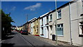
1
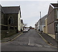
Unity Street, Aberdare
Viewed across Monk Street. Highland Place Unitarian Church http://www.geograph.org.uk/photo/4337551 is on the left.
Image: © Jaggery
Taken: 5 Feb 2015
0.01 miles
2
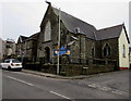
Highland Place Unitarian Church in Aberdare
The nameboard on the corner of Monk Street and Unity Street shows that the church was built in 1860, renovated in 1996.
Image: © Jaggery
Taken: 5 Feb 2015
0.03 miles
3
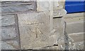
Ordnance Survey Cut Mark
This OS cut mark can be found on the front of the Unitarian Church. It marks a point 158.908m above mean sea level.
Image: © Adrian Dust
Taken: 1 Jun 2017
0.03 miles
4
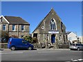
Chapel at Graig Isaf
Aberdare Unitarian Church, Aberdare.
Image: © Alan Hughes
Taken: 16 Mar 2020
0.03 miles
5
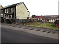
Fenced-off site on the north side of Highland Place, Aberdare
In early February 2015, little remains to indicate what used to be here.
Behind the fence are a few fragments of rubble, traffic cones and grass.
Image: © Jaggery
Taken: 5 Feb 2015
0.04 miles
6
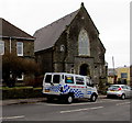
Silver Fox Karting van in Aberdare
Parked outside Highland Place Unitarian Church. http://www.geograph.org.uk/photo/4337551 Karting (or kart racing) is a motor sport with small, open, 4-wheeled vehicles called karts or go-karts, usually raced on scaled-down circuits.
Image: © Jaggery
Taken: 5 Feb 2015
0.04 miles
7
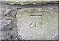
Ordnance Survey Cut Mark
This OS cut mark can be found on the wall of the Unitarian Church. It marks a point 156.835m above mean sea level.
Image: © Adrian Dust
Taken: 1 Jun 2017
0.04 miles
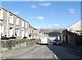
9
Highland Place, Aberdare
Residential street leading to Ty Fry.
Image: © Jonathan Billinger
Taken: 22 Aug 2013
0.04 miles
10
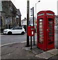
Old phonebox and new postbox in Aberdare
Alongside a bus stop on the corner of Ynysllwyd Street and Monk Street.
Image: © Jaggery
Taken: 5 Feb 2015
0.05 miles