IMAGES TAKEN NEAR TO
Glannant Street, ABERDARE, CF44 7PH
Introduction
This page details the photographs taken nearby to Glannant Street, CF44 7PH by members of the Geograph project.
The Geograph project started in 2005 with the aim of publishing, organising and preserving representative images for every square kilometre of Great Britain, Ireland and the Isle of Man.

There are currently over 7.5m images from over14,400 individuals and you can help contribute to the project by visiting https://www.geograph.org.uk
Image Map
Images are licensed for reuse under creativecommons.org/licenses/by-sa/2.0
Notes
- Clicking on the map will re-center to the selected point.
- The higher the marker number, the further away the image location is from the centre of the postcode.
Image Listing (238 Images Found)
Images are licensed for reuse under creativecommons.org/licenses/by-sa/2.0
Image
Details
Distance
1
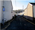
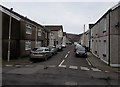
David Price Street, Aberdare
Viewed from Cross Street. A one-way traffic system, towards Little Wind Street,
is in force along David Price Street.
Image: © Jaggery
Taken: 19 Jan 2015
0.04 miles
2
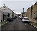
SE along Catherine Street, Aberdare
Looking towards Stuart Street and Elizabeth Street from the Ynysllwyd Street intersection.
Image: © Jaggery
Taken: 5 Feb 2015
0.06 miles
3
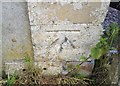
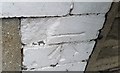
Ordnance Survey Cut Mark
This OS cut mark can be found on No15 Glan Nant Street. It marks a point 137.407m above mean sea level.
Image: © Adrian Dust
Taken: 1 Jun 2017
0.06 miles
4
Upper Regent Street, Aberdare
Viewed from Wind Street looking along Upper Regent Street towards Little Wind Street.
Image: © Jaggery
Taken: 19 Jan 2015
0.07 miles
5
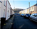
Ynysllwyd Street, Aberdare
NE along Ynysllwyd Street from Catherine Street towards Jenkin Street.
Image: © Jaggery
Taken: 5 Feb 2015
0.07 miles
6
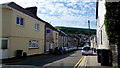
Ynys-Llwyd Street
Housing in Aberdare's Foundry Town.
Image: © Jonathan Billinger
Taken: 22 Aug 2013
0.08 miles
7
Ordnance Survey Cut Mark
This OS cut mark can be found on No17 Stuart Street. It marks a point 142.637m above mean sea level.
Image: © Adrian Dust
Taken: 1 Jun 2017
0.08 miles
8
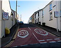
Albert Street, Aberdare
Albert Street climbs steeply away from Cross Street.
The speed limit reduces from 30mph to 20mph on the approach to a school.
Image: © Jaggery
Taken: 19 Jan 2015
0.08 miles
9
Location of the former Morning Star pub in Aberdare
A nameboard on the wall on the corner of Catherine Street and Ynysllwyd Street records the site of the Morning Star pub. Viewed in early February 2015, when various websites purporting to list current businesses are still showing the Morning Star as a pub on this corner.
Image: © Jaggery
Taken: 5 Feb 2015
0.09 miles
10
Wind Street towards Elizabeth Street, Aberdare
Viewed from the edge of Aberdare police station. http://www.geograph.org.uk/photo/4315719
Image: © Jaggery
Taken: 19 Jan 2015
0.09 miles