IMAGES TAKEN NEAR TO
Catherine Street, ABERDARE, CF44 7LU
Introduction
This page details the photographs taken nearby to Catherine Street, CF44 7LU by members of the Geograph project.
The Geograph project started in 2005 with the aim of publishing, organising and preserving representative images for every square kilometre of Great Britain, Ireland and the Isle of Man.

There are currently over 7.5m images from over14,400 individuals and you can help contribute to the project by visiting https://www.geograph.org.uk
Image Map
Images are licensed for reuse under creativecommons.org/licenses/by-sa/2.0
Notes
- Clicking on the map will re-center to the selected point.
- The higher the marker number, the further away the image location is from the centre of the postcode.
Image Listing (210 Images Found)
Images are licensed for reuse under creativecommons.org/licenses/by-sa/2.0
Image
Details
Distance
1
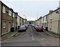
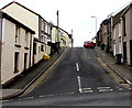
NW end of Catherine Street, Aberdare
Viewed across Monk Street looking towards Ynysllwyd Street.
Image: © Jaggery
Taken: 5 Feb 2015
0.01 miles
2
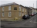
Location of the former Morning Star pub in Aberdare
A nameboard on the wall on the corner of Catherine Street and Ynysllwyd Street records the site of the Morning Star pub. Viewed in early February 2015, when various websites purporting to list current businesses are still showing the Morning Star as a pub on this corner.
Image: © Jaggery
Taken: 5 Feb 2015
0.01 miles
3
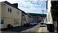
Ynys-Llwyd Street
Housing in Aberdare's Foundry Town.
Image: © Jonathan Billinger
Taken: 22 Aug 2013
0.02 miles
4
Mary Street, Aberdare
Viewed from Monk Street looking SE towards Ynysllwyd Street.
Image: © Jaggery
Taken: 5 Feb 2015
0.03 miles
5
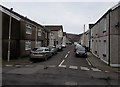
Jenkin Street, Aberdare
Jenkin Street ascends from Monk Street towards the left turn for Price Street.
Image: © Jaggery
Taken: 5 Feb 2015
0.03 miles
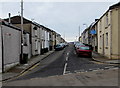
6
Ynysllwyd Street, Aberdare
NE along Ynysllwyd Street from Catherine Street towards Jenkin Street.
Image: © Jaggery
Taken: 5 Feb 2015
0.03 miles
7
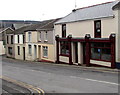
Upper Cut in Aberdare
There is no nameboard on the hair studio at 12 Monk Street, and the names on the windows and door are inconspicuous, so someone who has only a vague idea where Upper Cut is may give up looking for the salon.
Image: © Jaggery
Taken: 5 Feb 2015
0.04 miles
8
Catherine Street, Aberdare
Ahead is a boarded-up business on Monk Street.
Image: © Jonathan Billinger
Taken: 22 Aug 2013
0.04 miles
9
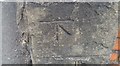
Ordnance Survey Cut Mark
This OS cut mark can be found on the wall of No55 Monk Street. It marks a point 143.625m above mean sea level.
Image: © Adrian Dust
Taken: 1 Jun 2017
0.04 miles
10
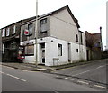
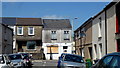
Boarded-up corner shop sold at auction, Aberdare
On the corner of Monk Street and Clifton Street, the name A.N.M. General Store remains on the derelict building viewed in early February 2015. A small SOLD label is on the For Sale by Auction board at a first floor window.
Image: © Jaggery
Taken: 5 Feb 2015
0.04 miles