IMAGES TAKEN NEAR TO
Rachel Street, ABERDARE, CF44 7LP
Introduction
This page details the photographs taken nearby to Rachel Street, CF44 7LP by members of the Geograph project.
The Geograph project started in 2005 with the aim of publishing, organising and preserving representative images for every square kilometre of Great Britain, Ireland and the Isle of Man.

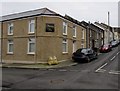
There are currently over 7.5m images from over14,400 individuals and you can help contribute to the project by visiting https://www.geograph.org.uk
Image Map
Images are licensed for reuse under creativecommons.org/licenses/by-sa/2.0
Notes
- Clicking on the map will re-center to the selected point.
- The higher the marker number, the further away the image location is from the centre of the postcode.
Image Listing (255 Images Found)
Images are licensed for reuse under creativecommons.org/licenses/by-sa/2.0
Image
Details
Distance
1
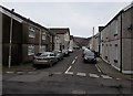
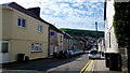
Ynysllwyd Street, Aberdare
NE along Ynysllwyd Street from Catherine Street towards Jenkin Street.
Image: © Jaggery
Taken: 5 Feb 2015
0.04 miles
2
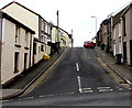
Jenkin Street, Aberdare
Jenkin Street ascends from Monk Street towards the left turn for Price Street.
Image: © Jaggery
Taken: 5 Feb 2015
0.05 miles
3
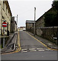
No entry to Griffith Street, Aberdare
A one-way system, towards Monk Street on this side, is in force along Griffith Street, where double yellow lines on both sides make parking illegal at any time. The former Calfaria Baptist Chapel, which closed in 2012, is on the right.
Image: © Jaggery
Taken: 5 Feb 2015
0.05 miles
4
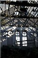
Derelict Bethania Chapel, Aberdare
Close to the centre of Aberdare, the sizeable Bethania Chapel is open to the elements and gradually disintegrating.
Image: © B Whitmore
Taken: 10 Oct 2009
0.05 miles
5
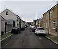
Ynys-Llwyd Street
Housing in Aberdare's Foundry Town.
Image: © Jonathan Billinger
Taken: 22 Aug 2013
0.05 miles
6
SE along Catherine Street, Aberdare
Looking towards Stuart Street and Elizabeth Street from the Ynysllwyd Street intersection.
Image: © Jaggery
Taken: 5 Feb 2015
0.06 miles
7
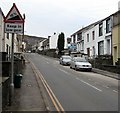
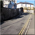
Keep in low gear for 16% gradient ahead, Monk Street, Aberdare
Moderately steep here, the road gets much steeper out of shot ahead. 16% is between 1 in 6 and 1 in 7.
Image: © Jaggery
Taken: 5 Feb 2015
0.06 miles
8
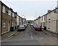
NW end of Catherine Street, Aberdare
Viewed across Monk Street looking towards Ynysllwyd Street.
Image: © Jaggery
Taken: 5 Feb 2015
0.06 miles
9
Location of the former Morning Star pub in Aberdare
A nameboard on the wall on the corner of Catherine Street and Ynysllwyd Street records the site of the Morning Star pub. Viewed in early February 2015, when various websites purporting to list current businesses are still showing the Morning Star as a pub on this corner.
Image: © Jaggery
Taken: 5 Feb 2015
0.07 miles
10
Wind Street towards Elizabeth Street, Aberdare
Viewed from the edge of Aberdare police station. http://www.geograph.org.uk/photo/4315719
Image: © Jaggery
Taken: 19 Jan 2015
0.07 miles