IMAGES TAKEN NEAR TO
Wind Street, ABERDARE, CF44 7ES
Introduction
This page details the photographs taken nearby to Wind Street, CF44 7ES by members of the Geograph project.
The Geograph project started in 2005 with the aim of publishing, organising and preserving representative images for every square kilometre of Great Britain, Ireland and the Isle of Man.

There are currently over 7.5m images from over14,400 individuals and you can help contribute to the project by visiting https://www.geograph.org.uk
Image Map
Images are licensed for reuse under creativecommons.org/licenses/by-sa/2.0
Notes
- Clicking on the map will re-center to the selected point.
- The higher the marker number, the further away the image location is from the centre of the postcode.
Image Listing (221 Images Found)
Images are licensed for reuse under creativecommons.org/licenses/by-sa/2.0
Image
Details
Distance
1
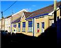
Salvation Army Aberdare Corps
Viewed across Wind Street on a day of springlike sunshine but wintry temperatures in January 2015.
Image: © Jaggery
Taken: 19 Jan 2015
0.03 miles
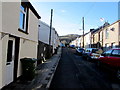
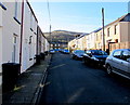
2
Nith Street, Aberdare
Viewed from Wind Street looking along Nith Street towards Albert Street.
Image: © Jaggery
Taken: 19 Jan 2015
0.03 miles
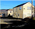
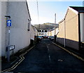
3
Bond Street, Aberdare
Looking SW along Bond Street from Wind Street.
Image: © Jaggery
Taken: 19 Jan 2015
0.05 miles
4
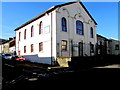
Urdd Centre in Aberdare
Located in the former Soar chapel on the corner of Wind Street and Oak Street, the Urdd Centre houses Cylch Meithrin Aberdâr, a Welsh medium pre-school for children aged 2 to school age, and their families.
Image: © Jaggery
Taken: 19 Jan 2015
0.05 miles
5
Upper Regent Street, Aberdare
Viewed from Wind Street looking along Upper Regent Street towards Little Wind Street.
Image: © Jaggery
Taken: 19 Jan 2015
0.05 miles
6
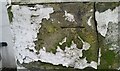
Ordnance Survey Cut Mark
This OS cut mark can be found on the east angle of the Soar Chapel. It marks a point 134.764m above mean sea level.
Image: © Adrian Dust
Taken: 7 Dec 2020
0.06 miles
7
David Price Street, Aberdare
Viewed from Cross Street. A one-way traffic system, towards Little Wind Street,
is in force along David Price Street.
Image: © Jaggery
Taken: 19 Jan 2015
0.06 miles
8
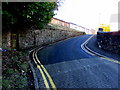
Albert Street, Aberdare
Albert Street climbs steeply away from Cross Street.
The speed limit reduces from 30mph to 20mph on the approach to a school.
Image: © Jaggery
Taken: 19 Jan 2015
0.06 miles
9
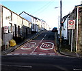
Dumfries Street, Aberdare
Dumfries Street climbs steeply away from Cross Street.
The speed limit reduces from 30mph to 20mph on the approach to a school.
Image: © Jaggery
Taken: 19 Jan 2015
0.06 miles
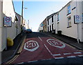
10
No parking in Bute Terrace, Aberdare
Between Cardiff Street and Bute Street, double yellow lines on both
sides of the road make parking in Bute Terrace illegal at any time.
Image: © Jaggery
Taken: 19 Jan 2015
0.07 miles