IMAGES TAKEN NEAR TO
Seymour Street, ABERDARE, CF44 7BL

Introduction

This page details the photographs taken nearby to Seymour Street, CF44 7BL by members of the Geograph project.

The Geograph project started in 2005 with the aim of publishing, organising and preserving representative images for every square kilometre of Great Britain, Ireland and the Isle of Man.

There are currently over 7.5m images from over14,400 individuals and you can help contribute to the project by visiting https://www.geograph.org.uk

Image Map


Images are licensed for reuse under creativecommons.org/licenses/by-sa/2.0
Notes
  • Clicking on the map will re-center to the selected point.
  • The higher the marker number, the further away the image location is from the centre of the postcode.

Image Listing (299 Images Found)

Images are licensed for reuse under creativecommons.org/licenses/by-sa/2.0
  • ...
Image
Details
Distance
1
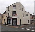
Former Wedding Shop for sale, Aberdare
This shop on the corner of Whitcombe Street and Seymour Street used to be One Stop Wedding Shop.
Image: © Jaggery Taken: 3 May 2014
0.01 miles
2
Trinity Chapel, Weatherall Street Aberdare
Trinity Chapel on the corner of Weatherall Street, opposite the Aberdare Palladium. Built in 1867.
Image: © Darren W Rees Taken: 6 Feb 2008
0.02 miles
3
The Whitcombe Inn, Aberdare
Pub located close to the town centre, on the corner of Whitcombe Street and Pembroke Street.
Image: © Jaggery Taken: 26 May 2010
0.03 miles
4
Teeth, Aberdare
The white on black TEETH sign hangs from a bracket on the wall of Whitcombe Dental Surgery, 19 Whitcombe Street.
Image: © Jaggery Taken: 3 May 2014
0.03 miles
5
The Gloster Arms in Aberdare
Pub on the corner of Whitcombe Street and Dean Street. The pub previously had a slightly different name. It was The Glosters Arms in a Google Earth Street View taken in August 2009.
Image: © Jaggery Taken: 3 May 2014
0.03 miles
6
Ordnance Survey Cut Mark
This OS cut mark can be found on No19 Whitcombe Street. It marks a point 126.388m above mean sea level.
Image: © Adrian Dust Taken: 1 Jun 2017
0.03 miles
7
Boulders lining a vacant corner in Aberdare
On the corner of Whitcombe Street (on the left) and Seymour Street.
Image: © Jaggery Taken: 3 May 2014
0.04 miles
8
Joe's, Aberdare
Cafe & takeaway, restaurant & fish bar at 21 Whitcombe Street, on the corner of Dean Street. Sheppards perfumery and pharmacy is on the right.
Image: © Jaggery Taken: 3 May 2014
0.04 miles
9
Ordnance Survey Cut Mark
This OS cut mark can be found on the old dairy, Gloucester Street. It marks a point 124.813m above mean sea level.
Image: © Adrian Dust Taken: 1 Jun 2017
0.04 miles
10
Dean Street - viewed from Whitcombe Street
Image: © Betty Longbottom Taken: 27 Jun 2019
0.04 miles
  • ...