IMAGES TAKEN NEAR TO
Cardiff Road, ABERDARE, CF44 6UU
Introduction
This page details the photographs taken nearby to Cardiff Road, CF44 6UU by members of the Geograph project.
The Geograph project started in 2005 with the aim of publishing, organising and preserving representative images for every square kilometre of Great Britain, Ireland and the Isle of Man.

There are currently over 7.5m images from over14,400 individuals and you can help contribute to the project by visiting https://www.geograph.org.uk
Image Map
Images are licensed for reuse under creativecommons.org/licenses/by-sa/2.0
Notes
- Clicking on the map will re-center to the selected point.
- The higher the marker number, the further away the image location is from the centre of the postcode.
Image Listing (62 Images Found)
Images are licensed for reuse under creativecommons.org/licenses/by-sa/2.0
Image
Details
Distance
1
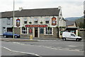
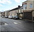
The Plough Inn, Aberaman
Pub on the corner of Cardiff Road and Lewis Street.
The pub, dating from 1848, was originally named The Plough & Barrow.
Image: © Jaggery
Taken: 7 May 2010
0.01 miles
2
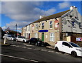
Plough Inn, Aberaman
At 1 Lewis Street on the corner of the B4275 Cardiff Road.
Image: © Jaggery
Taken: 4 Feb 2019
0.03 miles
3
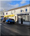
Louise's Hair Design, Aberaman
Lewis Street hairdresser next door to Lewis Street Motor Parts.
Image: © Jaggery
Taken: 4 Feb 2019
0.03 miles
4
Sumbul's in Aberaman
Lewis Street side of the Turkish restaurant & takeaway at 134 Cardiff Road.
Image: © Jaggery
Taken: 4 Feb 2019
0.05 miles
5
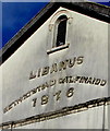
Libanus 1876, Lewis Street, Aberaman
The inscription in Welsh on Libanus Court flats https://www.geograph.org.uk/photo/1846320 records the 1876 rebuild of
Libanus Calvinistic Methodist Chapel built in 1848. The chapel closed down c1990.
Image: © Jaggery
Taken: 4 Feb 2019
0.05 miles
6
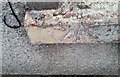
Ordnance Survey Cut Mark
This OS cut mark can be found on No102 Brook Street. It marks a point 133.179m above mean sea level.
Image: © Adrian Dust
Taken: 15 Apr 2018
0.05 miles
7
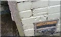
Ordnance Survey Rivet
This OS cut mark can be found on the sill of No19 Davis Street . It marks a point 128.364m above mean sea level.
Image: © Adrian Dust
Taken: 15 Apr 2018
0.06 miles
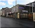
8
Lewis Street speed bump, Aberaman
Painted white triangles draw attention to the bump.
Pressings ironing service shop is behind the shuttered shop.
Image: © Jaggery
Taken: 4 Feb 2019
0.06 miles
9
Sunny side of Davis Street, Aberaman
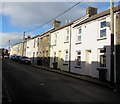
Viewed from the corner of Beddoe Street at 1:25pm on February 4th 2019.
Image: © Jaggery
Taken: 4 Feb 2019
0.07 miles
10
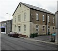
Libanus Court, Lewis Street, Aberaman
Now converted into flats, Libanus Court opened in 1847 as Libanus Welsh Calvinistic Methodist Chapel. The date shown on the front of the building, 1876, https://www.geograph.org.uk/photo/6051650 was when it underwent its last major rebuild as a chapel. The chapel closed down c1990.
Image: © Jaggery
Taken: 7 May 2010
0.07 miles