IMAGES TAKEN NEAR TO
Tudor Place, ABERDARE, CF44 6UE
Introduction
This page details the photographs taken nearby to Tudor Place, CF44 6UE by members of the Geograph project.
The Geograph project started in 2005 with the aim of publishing, organising and preserving representative images for every square kilometre of Great Britain, Ireland and the Isle of Man.

There are currently over 7.5m images from over14,400 individuals and you can help contribute to the project by visiting https://www.geograph.org.uk
Image Map
Images are licensed for reuse under creativecommons.org/licenses/by-sa/2.0
Notes
- Clicking on the map will re-center to the selected point.
- The higher the marker number, the further away the image location is from the centre of the postcode.
Image Listing (58 Images Found)
Images are licensed for reuse under creativecommons.org/licenses/by-sa/2.0
Image
Details
Distance
1
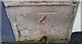
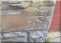
Ordnance Survey Cut Mark
This OS cut mark can be found on No10 King Street. It marks a point 123.033m above mean sea level.
Image: © Adrian Dust
Taken: 15 Apr 2018
0.10 miles
2
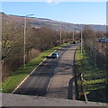
A4059 SE of a footbridge, Aberdare
Viewed from this http://www.geograph.org.uk/photo/4317633 footbridge.
Image: © Jaggery
Taken: 19 Jan 2015
0.12 miles
3
Ynys-Lwyd Road, Aberaman, Aberdare
Looking east from the B4275 Cardiff Road end. The left turn ahead is into Primrose Terrace. http://www.geograph.org.uk/photo/4315944
Image: © Jaggery
Taken: 19 Jan 2015
0.13 miles
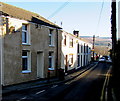
4
Primrose Terrace, Aberaman, Aberdare
Looking north from Ynys-Lwyd Road.
Image: © Jaggery
Taken: 19 Jan 2015
0.14 miles
5
Ordnance Survey Cut Mark
This OS cut mark can be found on the wall of No77 Cardiff Road. It marks a point 123.828m above mean sea level.
Image: © Adrian Dust
Taken: 22 Apr 2018
0.15 miles
6
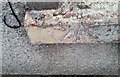
Ordnance Survey Rivet
This OS cut mark can be found on the sill of No19 Davis Street . It marks a point 128.364m above mean sea level.
Image: © Adrian Dust
Taken: 15 Apr 2018
0.15 miles
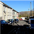
7
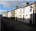
Sunny side of Davis Street, Aberaman
Viewed from the corner of Beddoe Street at 1:25pm on February 4th 2019.
Image: © Jaggery
Taken: 4 Feb 2019
0.15 miles
8
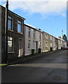
Davis Street houses, Aberaman
Looking to the northwest from the corner of Beddoe Street.
Saron Chapel https://www.geograph.org.uk/photo/6053934 is behind the camera.
Image: © Jaggery
Taken: 4 Feb 2019
0.16 miles
9
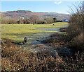
Horses in a field on the south bank of the Afon Cynon, Aberdare
Near this http://www.geograph.org.uk/photo/4317633 footbridge over the A4059.
The distant line of trees mark the course of the Afon Cynon.
In mid January 2015, patchy hoar frost remains on grass not reach by the sun's rays.
Image: © Jaggery
Taken: 19 Jan 2015
0.16 miles
10
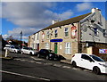
Plough Inn, Aberaman
At 1 Lewis Street on the corner of the B4275 Cardiff Road.
Image: © Jaggery
Taken: 4 Feb 2019
0.16 miles