IMAGES TAKEN NEAR TO
Rhodfa Maes Nant, CF44 6TQ
Introduction
This page details the photographs taken nearby to Rhodfa Maes Nant, CF44 6TQ by members of the Geograph project.
The Geograph project started in 2005 with the aim of publishing, organising and preserving representative images for every square kilometre of Great Britain, Ireland and the Isle of Man.

There are currently over 7.5m images from over14,400 individuals and you can help contribute to the project by visiting https://www.geograph.org.uk
Image Map
Images are licensed for reuse under creativecommons.org/licenses/by-sa/2.0
Notes
- Clicking on the map will re-center to the selected point.
- The higher the marker number, the further away the image location is from the centre of the postcode.
Image Listing (33 Images Found)
Images are licensed for reuse under creativecommons.org/licenses/by-sa/2.0
Image
Details
Distance
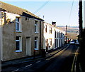
1
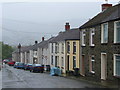
Gwawr Street, Aberaman
Miners' cottages ascending the hillside of the Cynon valley south of Aberdare.
Image: © Jonathan Billinger
Taken: 4 Oct 2008
0.07 miles
2
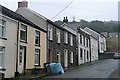
Gwawr Street, Aberaman
Miners' cottages ascending the hillside with newer properties higher up.
Image: © Graham Horn
Taken: 4 Oct 2008
0.08 miles
3
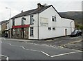
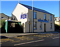
Blaengwawr Inn, Aberaman
Located on the corner of Cardiff Road and Club Street. Pub with a beer garden.
Image: © Jaggery
Taken: 7 May 2010
0.12 miles
4
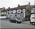
Temple Bar, Aberaman
Pub located on Cardiff Road.
Among the attractions advertised on the front of the pub are Sky Sports, restaurant, real ale, beer garden and games room.
Image: © Jaggery
Taken: 7 May 2010
0.16 miles
5
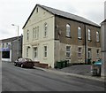
Libanus Court, Lewis Street, Aberaman
Now converted into flats, Libanus Court opened in 1847 as Libanus Welsh Calvinistic Methodist Chapel. The date shown on the front of the building, 1876, https://www.geograph.org.uk/photo/6051650 was when it underwent its last major rebuild as a chapel. The chapel closed down c1990.
Image: © Jaggery
Taken: 7 May 2010
0.16 miles
6
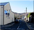
Club Street, Aberaman, Aberdare
Viewed across the B4275 Cardiff Road. Blaengwawr Inn http://www.geograph.org.uk/photo/4315903 is on the left.
Image: © Jaggery
Taken: 19 Jan 2015
0.16 miles
7
Bus stop
Bus stop alongside the Blaengwawr Inn, Aberaman.
Image: © Alan Hughes
Taken: 16 Mar 2020
0.17 miles
8
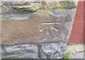
Ordnance Survey Cut Mark
This OS cut mark can be found on the wall of No77 Cardiff Road. It marks a point 123.828m above mean sea level.
Image: © Adrian Dust
Taken: 22 Apr 2018
0.17 miles
9
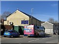
Blaengwawr Inn, Aberaman, Aberdare
The pub at 373 Cardiff Road has had a makeover since this http://www.geograph.org.uk/photo/1846094 view taken in May 2010.
Image: © Jaggery
Taken: 19 Jan 2015
0.17 miles
10
Ynys-Lwyd Road, Aberaman, Aberdare
Looking east from the B4275 Cardiff Road end. The left turn ahead is into Primrose Terrace. http://www.geograph.org.uk/photo/4315944
Image: © Jaggery
Taken: 19 Jan 2015
0.19 miles