IMAGES TAKEN NEAR TO
Maes-y-Deri, ABERDARE, CF44 6TG
Introduction
This page details the photographs taken nearby to Maes-y-Deri, CF44 6TG by members of the Geograph project.
The Geograph project started in 2005 with the aim of publishing, organising and preserving representative images for every square kilometre of Great Britain, Ireland and the Isle of Man.

There are currently over 7.5m images from over14,400 individuals and you can help contribute to the project by visiting https://www.geograph.org.uk
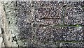
Image Map
Images are licensed for reuse under creativecommons.org/licenses/by-sa/2.0
Notes
- Clicking on the map will re-center to the selected point.
- The higher the marker number, the further away the image location is from the centre of the postcode.
Image Listing (49 Images Found)
Images are licensed for reuse under creativecommons.org/licenses/by-sa/2.0
Image
Details
Distance
1
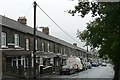
Clarence Terrace, Aberaman
The houses here are stone built. The roof line follows the angle of the street rather than stepped down every houses or two. So the attics must be high at one end and low at the other.
Image: © Graham Horn
Taken: 4 Oct 2008
0.03 miles
2
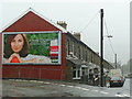
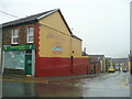
The haves and the have nots
A juxtaposition of multi-national celebrity based advertising and a row of cottages in Aberaman in the Cynon valley.
Image: © Jonathan Billinger
Taken: 4 Oct 2008
0.06 miles
3
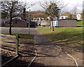
Oaklands Primary School, Aberaman
Viewed from this http://www.geograph.org.uk/photo/3885121 side entrance.
Image: © Jaggery
Taken: 22 Feb 2014
0.07 miles
4
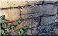
Ordnance Survey Cut Mark
This OS cut mark can be found on the Bethany Chapel. It marks a point 143.632m above mean sea level.
Image: © Adrian Dust
Taken: 19 Jan 2018
0.07 miles
5
Jubilee Bakery, Aberaman
Or, rather, an ex-bakery on the corner of Jubilee Road and Dyffryn Street.
Image: © Jonathan Billinger
Taken: 4 Oct 2008
0.10 miles
6
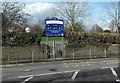
Side entrance to Oaklands Primary School, Aberaman
From Cardiff Road. An arrow on the nameboard points the way to the main entrance on Maes-y-Deri.
Image: © Jaggery
Taken: 22 Feb 2014
0.10 miles
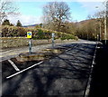
7
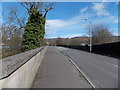
Across Aberaman Bridge, Aberaman
The B4275 Cardiff Road crosses the bridge over the River Aman.
Image: © Jaggery
Taken: 22 Feb 2014
0.11 miles
8
Ordnance Survey Cut Mark
This OS cut mark can be found on Grove Cottage. It marks a point 123.091m above mean sea level.
Image: © Adrian Dust
Taken: 19 Jan 2018
0.11 miles
9
Cardiff Road, Aberaman
The B4275 Cardiff Road heads away from a side entrance http://www.geograph.org.uk/photo/3885121 to Oaklands Primary School.
Image: © Jaggery
Taken: 22 Feb 2014
0.11 miles
10
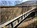
Steel girder and concrete blockwork bridge
Bridge over the River Aman.
Image: © Alan Hughes
Taken: 27 Mar 2019
0.12 miles