1
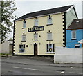
The Kings, Aberaman
Pub at 263 Cardiff Road. Previously the Kings Head Inn (this name is still visible under the eaves on the right side of the building).
Image: © Jaggery
Taken: 7 May 2010
0.05 miles
2
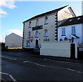
Auction board on a former pub, Cardiff Road, Aberaman
Viewed in February 2019 when only the s of The Kings name
remains on the sign seen here https://www.geograph.org.uk/photo/1846379 intact in May 2010.
UPDATE 2020. Now a wellbeing centre to tackle poverty caused by Coronavirus (COVID-19).
Image: © Jaggery
Taken: 4 Feb 2019
0.08 miles
3
Derelict former The Kings, Cardiff Road, Aberaman
Viewed in February 2019. This May 2010 photo https://www.geograph.org.uk/photo/1846379 shows The Kings when open for business.
Image: © Jaggery
Taken: 4 Feb 2019
0.08 miles
4
Zebra crossing, Cardiff Road, Aberaman
Across the B4275 Cardiff Road. The derelict former The Kings pub https://www.geograph.org.uk/photo/6047492 is in the background.
Image: © Jaggery
Taken: 4 Feb 2019
0.09 miles
5
Aberaman Public Hall commemoration plinth
Located on the north side of Cardiff Road, just east of Lewis Street.
The plaque https://www.geograph.org.uk/photo/6047493 on the plinth commemorates the building formerly housing Aberaman Public Hall, Institute, Free Library and Grand Theatre. It was built on this site in 1908 and totally destroyed by fire in October 1994. The plaque ends with these words
"A wonderful building. The centre of the life of Aberaman for nearly a century".
Image: © Jaggery
Taken: 7 May 2010
0.09 miles
6
Aberaman Public Hall commemoration plaque
On this https://www.geograph.org.uk/photo/1846469 plinth.
Image: © Jaggery
Taken: 4 Feb 2019
0.09 miles
7
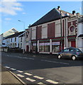
Mill Street Carpets Discount Centre, Cardiff Road, Aberaman
Viewed in February 2019. A pool hall was here in May 2010. https://www.geograph.org.uk/photo/1846481
Image: © Jaggery
Taken: 4 Feb 2019
0.09 miles
8
Regent Street, Aberaman
Main road running through Aberaman.
Image: © Alan Hughes
Taken: 16 Mar 2020
0.10 miles
9
Silver City in Aberaman
Chinese takeaway at 170 Cardiff Road.
Image: © Jaggery
Taken: 4 Feb 2019
0.10 miles
10
Rock Inn, 167 Cardiff Road, Aberaman
Pub on the corner of Lewis Street.
Image: © Jaggery
Taken: 4 Feb 2019
0.11 miles


