IMAGES TAKEN NEAR TO
Lewis Street, ABERDARE, CF44 6PY
Introduction
This page details the photographs taken nearby to Lewis Street, CF44 6PY by members of the Geograph project.
The Geograph project started in 2005 with the aim of publishing, organising and preserving representative images for every square kilometre of Great Britain, Ireland and the Isle of Man.

There are currently over 7.5m images from over14,400 individuals and you can help contribute to the project by visiting https://www.geograph.org.uk
Image Map
Images are licensed for reuse under creativecommons.org/licenses/by-sa/2.0
Notes
- Clicking on the map will re-center to the selected point.
- The higher the marker number, the further away the image location is from the centre of the postcode.
Image Listing (59 Images Found)
Images are licensed for reuse under creativecommons.org/licenses/by-sa/2.0
Image
Details
Distance
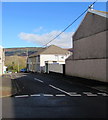
1
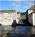
Minor crossroads in Aberaman
Beddoe Street is on the camera side and ahead. Lewis Street is on the left and right.
Image: © Jaggery
Taken: 4 Feb 2019
0.01 miles
2
Crossroads in Aberaman
Beddoe Street (on the camera side and ahead) crosses Lewis Street.
Image: © Jaggery
Taken: 4 Feb 2019
0.01 miles
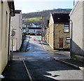
3
Lewis Street speed bump, Aberaman
Painted white triangles draw attention to the bump.
Pressings ironing service shop is behind the shuttered shop.
Image: © Jaggery
Taken: 4 Feb 2019
0.02 miles
4
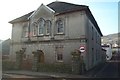
Saron Chapel, Davis Street, Aberaman
Saron Chapel, Davies Street, Aberaman.
Image: © Darren W Rees
Taken: 6 Feb 2008
0.02 miles
5
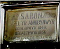
Welsh inscription on Saron Chapel, Aberaman
Faded in February 2019, the inscription records that the independent chapel https://www.geograph.org.uk/photo/6053934
was erected in 1849, enlarged in 1856, renovated in 1871 and 1890.
Image: © Jaggery
Taken: 4 Feb 2019
0.02 miles
6
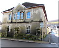
North side of Grade II listed Saron Chapel, Aberaman
The Davis Street side of the chapel on the corner of Beddoe Street. The Welsh inscription https://www.geograph.org.uk/photo/6053948 on the wall records that the building was erected in 1849 as an independent chapel. It was enlarged in 1856, renewed in 1871 and 1890. Grade II listed in 1999 as a mid 19th century chapel foundation retaining an exceptionally fine interior of the later 19th century.
Image: © Jaggery
Taken: 4 Feb 2019
0.02 miles
7
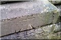
Ordnance Survey Cut Mark
This OS cut mark can be found on the all of the Saron Chapel. It marks a point 124.554m above mean sea level.
Image: © Adrian Dust
Taken: 15 Apr 2018
0.02 miles
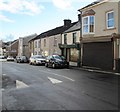
8
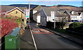
Beddoe Street, Aberaman
The 30mph speed limit on Cardiff Road drops to 20mph along Beddoe Street.
Image: © Jaggery
Taken: 4 Feb 2019
0.03 miles
9
Junction of Beddoe Street and Davis Street, Aberaman
Looking to the NNE along Beddoe Street.
Image: © Jaggery
Taken: 4 Feb 2019
0.03 miles
10
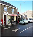
Glitchbusters Computing and the village post office, Aberaman
In February 2019 the village post office is inside Glitchbusters Computing shop at 41 Lewis Street.
This photo https://www.geograph.org.uk/photo/1846326 shows the post office at 41 Lewis Street in May 2010.
Image: © Jaggery
Taken: 4 Feb 2019
0.03 miles