1
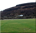
White house on a hillside, Cwmaman
Viewed across a football field on the south side of Glanaman Road.
Image: © Jaggery
Taken: 22 Feb 2014
0.09 miles
2
Children's playground in Cwmaman
Viewed from the entrance gate at the edge of Glanaman Road.
Image: © Jaggery
Taken: 22 Feb 2014
0.11 miles
3
Warning notice at the edge of Glanaman Road recreation ground, Cwmaman
The Rhondda Cynon Taff County Borough Council's Leisure and Tourism Department's notice
lists three activities that are "strictly forbidden on these premises".
Listed are playing of golf, riding of motorcycles, horse riding.
No mention is made of lighting a bonfire, digging up the field or erecting a 3-ring circus...
Image: © Jaggery
Taken: 22 Feb 2014
0.14 miles
4
Sports changing room building in Cwmaman
In a recreation ground on the south side of Glanaman Road.
Image: © Jaggery
Taken: 22 Feb 2014
0.14 miles
5
Glanaman Road bus stops, Cwmaman
These bus stops are one stop away from the terminus near the western edge of the village (ahead).
A bus stopping at or passing the stop on the left side of the road will stop at or pass the stop on the right side a few minutes later.
Image: © Jaggery
Taken: 22 Feb 2014
0.14 miles
6
Houses on the north side of Glanaman Road, Cwmaman
Viewed looking east.
Image: © Jaggery
Taken: 22 Feb 2014
0.14 miles
7
Slow down - playground ahead, Glanaman Road, Cwmaman
The entrance to the playground http://www.geograph.org.uk/photo/3923888 is behind the tree on the left.
Image: © Jaggery
Taken: 22 Feb 2014
0.15 miles
8
Ordnance Survey Rivet
This OS rivet can be found on the window sill of No44 Glanaman Road. It marks a point 188.632m above mean sea level.
Image: © Adrian Dust
Taken: 22 Apr 2018
0.15 miles
9
Glanaman Road houses, Cwmaman
The houses are opposite a recreation ground.
Image: © Jaggery
Taken: 22 Feb 2014
0.16 miles
10
The Goddess by Peter Boyd at Cwmaman Sculpture Trail
The Goddess sculpture by Peter Boyd forms part of the Cwmaman Sculpture Trail. It is located very near St Joseph's Church, Cwmaman.
Image: © Darren W Rees
Taken: 22 Jul 2008
0.19 miles


