IMAGES TAKEN NEAR TO
Alice Place, ABERDARE, CF44 6NY
Introduction
This page details the photographs taken nearby to Alice Place, CF44 6NY by members of the Geograph project.
The Geograph project started in 2005 with the aim of publishing, organising and preserving representative images for every square kilometre of Great Britain, Ireland and the Isle of Man.

There are currently over 7.5m images from over14,400 individuals and you can help contribute to the project by visiting https://www.geograph.org.uk
Image Map
Images are licensed for reuse under creativecommons.org/licenses/by-sa/2.0
Notes
- Clicking on the map will re-center to the selected point.
- The higher the marker number, the further away the image location is from the centre of the postcode.
Image Listing (66 Images Found)
Images are licensed for reuse under creativecommons.org/licenses/by-sa/2.0
Image
Details
Distance
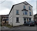
1
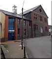
Cwmaman Public Hall & Institute
Viewed across Fforchaman Road. This is the location of Cwmaman Theatre & Cinema and Cwmaman Health Suite. The premises are also used by local community groups, clubs and organisations. Special events include education courses, seminars and gigs.
Cwmaman Institute was established in 1868 as a reading room, in a rent-free house donated by the Cwmaman Coal Company. A library was added shortly afterwards, giving a place where local people could read books and children could be educated.
In 1884, a committee of officials at Cwmaman Colliery started a scheme whereby a halfpenny in each pound was deducted weekly from the colliery workmen's wages. Thus the movement to establish a purpose-built Public Hall & Institute began. In March 1892 Lord Aberdare opened the building seen here. It provided the village with a new complex, including a public hall with seating for c700 people, reading rooms, a billiards room and a caretaker's cottage.
During the 20th century, the fate of the Institute was inevitably linked to the demise of coal mining in the Cynon Valley. The closure of local collieries from the early 1960s onwards made it harder for the Institute to raise local funding and commitment. The fabric of the building deteriorated during the 1960s and 1970s. At the same time, membership of local groups and societies grew and there was new interest in maintaining the building as a community centre for Cwmaman, its current use.
Image: © Jaggery
Taken: 22 Feb 2014
0.00 miles
2
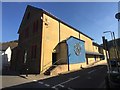
Cwmaman Theatre
The Royal Cwmaman Theatre. https://theroyalcwmamanhall.com
The hall is where the Stereophonics, who came from Cwmaman, first performed in the 1990s. https://en.m.wikipedia.org/wiki/Cwmaman
Image: © Alan Hughes
Taken: 27 Mar 2019
0.01 miles
3
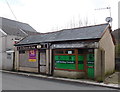
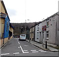
Betting shop and a former butchers shop in Cwmaman
Viewed across Fforchaman Road. ACN Betting Limited on the right is in premises formerly occupied by Cynthia's Boutique - a ghost of that name remains on the nameboard. A notice on the boarded-up former C.D.Davies & Son butchers shop on the left shows that the shop was to be auctioned on December 5th 2013. Viewed on February 22nd 2014.
Image: © Jaggery
Taken: 22 Feb 2014
0.01 miles
4
Old coal dram in Alice Place, Cwmaman
A dram was a truck on rails that was used in coal mining, a reminder that Cwmaman used to be a coal mining village.
Image: © Jaggery
Taken: 22 Feb 2014
0.01 miles
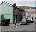
5
Alice Place, Cwmaman
Alice Place is a short street between Fforchaman Road on this side and the north bank of the Aman River ahead. A brown sign on the right shows that there is overflow parking ahead.
Cwmaman Public Hall & Institute http://www.geograph.org.uk/photo/3905153 is on the left.
Image: © Jaggery
Taken: 22 Feb 2014
0.01 miles
6
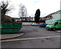
Bottle bank and overflow car park, Alice Place, Cwmaman
Located on the north bank of the Aman River, about 30 metres south of Fforchaman Road.
Image: © Jaggery
Taken: 22 Feb 2014
0.02 miles
7
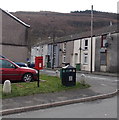
Postbox and litter bin in Cwmaman
On the corner of Fforchaman Road and Aman Court, at the edge of a small car park.
Image: © Jaggery
Taken: 22 Feb 2014
0.03 miles
8
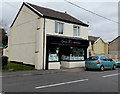
Queen Ti?s Tearooms, Cwmaman
Located at 5 Fforchaman Road.
Image: © Jaggery
Taken: 22 Feb 2014
0.03 miles
9
North side of the Shepherds Arms, Cwmaman
The pub on the corner of Fforchaman Road and Pwllfa Road dates from 1850.
It was named after Thomas Shepherd, the founder of Cwmaman Colliery.
Image: © Jaggery
Taken: 22 Feb 2014
0.03 miles
10
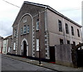
Former Seion Baptist chapel in Cwmaman
Located in Cwmneol Place, this building was an 1891 rebuild. The original chapel here was built c1860, in the early days of the transformation of Cwmaman from a small rural community to a mining village. Seion closed in 2013.
Image: © Jaggery
Taken: 22 Feb 2014
0.03 miles