IMAGES TAKEN NEAR TO
Morris Street, ABERDARE, CF44 6HW
Introduction
This page details the photographs taken nearby to Morris Street, CF44 6HW by members of the Geograph project.
The Geograph project started in 2005 with the aim of publishing, organising and preserving representative images for every square kilometre of Great Britain, Ireland and the Isle of Man.

There are currently over 7.5m images from over14,400 individuals and you can help contribute to the project by visiting https://www.geograph.org.uk
Image Map
Images are licensed for reuse under creativecommons.org/licenses/by-sa/2.0
Notes
- Clicking on the map will re-center to the selected point.
- The higher the marker number, the further away the image location is from the centre of the postcode.
Image Listing (70 Images Found)
Images are licensed for reuse under creativecommons.org/licenses/by-sa/2.0
Image
Details
Distance
1
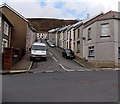
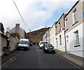
Spencer Street Cwmaman
Viewed from Cwmneol Street looking across Milton Street up Spencer Street towards Morris Street.
Image: © Jaggery
Taken: 22 Feb 2014
0.03 miles
2
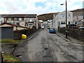
Cwmneol Street and Spencer Street, Cwmaman
Looking along Cwmneol Street and Spencer Street towards Morris Street
from the NW side of this http://www.geograph.org.uk/photo/3904712 former railway bridge.
Image: © Jaggery
Taken: 22 Feb 2014
0.03 miles
3
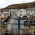
View NW from a former railway bridge in Cwmaman
Viewed from here http://www.geograph.org.uk/photo/3904742 along Cwmneol Street and Spencer Street towards Morris Street.
Image: © Jaggery
Taken: 22 Feb 2014
0.04 miles
4
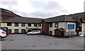
Cwmaman Care Centre
Residential care home set back from Morris Street.
Image: © Jaggery
Taken: 22 Feb 2014
0.04 miles
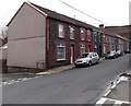
5
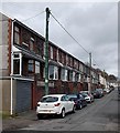
Morris Street houses, Cwmaman
Viewed from the Mountain Road end.
Image: © Jaggery
Taken: 22 Feb 2014
0.05 miles
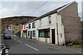
6
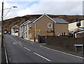
Mountain Road, Cwmaman
Mountain Road climbs away from Fforchaman Road. The road sign on the right warns of a children's playground nearby.
Image: © Jaggery
Taken: 22 Feb 2014
0.06 miles
7
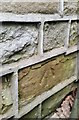
Ordnance Survey Cut Mark
This OS cut mark can be found on No6 Mountain Road. It marks a point 203.302m above mean sea level.
Image: © Adrian Dust
Taken: 22 Apr 2018
0.07 miles
8
NW end of Mountain Road, Cwmaman
Mountain Road ends at a wall and kissing gate ahead. http://www.geograph.org.uk/photo/3923731
Image: © Jaggery
Taken: 22 Feb 2014
0.07 miles
9
From Fforchaman Road to Mountain Road, Cwmaman
Fforchaman Road in the foreground extends as far as the Prospect Place
junction, on the right a few metres beyond a bus stop and bus shelter.
Beyond the junction, the road is Mountain Road.
Julie's Hair Salon http://www.geograph.org.uk/photo/3921600 is on the right.
Image: © Jaggery
Taken: 22 Feb 2014
0.07 miles
10
Milton Street south of the Cwmneol Street junction, Cwmaman
Viewed from the corner of Spencer Street. Cwmneol Street is on the left.
Image: © Jaggery
Taken: 22 Feb 2014
0.07 miles