1
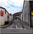
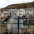
Cwmneol Street, Cwmaman
Viewed across Fforchaman Road. Chun Ho Chinese takeaway http://www.geograph.org.uk/photo/3857324 is on the left.
Image: © Jaggery
Taken: 22 Feb 2014
0.03 miles
2
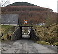
Former railway bridge over Cwmneol Street, Cwmaman
This is the SE side of the bridge, headroom 9' 9" (3 metres).
Image: © Jaggery
Taken: 22 Feb 2014
0.03 miles
3
NW side of a former railway bridge, Cwmneol Street, Cwmaman
Headroom is shown as 9' 9" (3 metres). The bridge now carries a public footpath instead of a railway.
Image: © Jaggery
Taken: 22 Feb 2014
0.03 miles
4
Steps up to a footpath across a former railway bridge in Cwmaman
The steps ascend from Cwmneol Street to here. http://www.geograph.org.uk/photo/3904742
Image: © Jaggery
Taken: 22 Feb 2014
0.03 miles
5
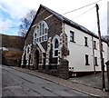
Bethel House, Cwmneol Street, Cwmaman
Former chapel converted to flats.
Image: © Jaggery
Taken: 22 Feb 2014
0.03 miles
6
Across a former railway bridge in Cwmaman
A public footpath has replaced railway lines across this http://www.geograph.org.uk/photo/3904730 bridge over Cwmneol Street.
Image: © Jaggery
Taken: 22 Feb 2014
0.04 miles
7
Ordnance Survey Rivet
This OS rivet can be found on the Moriah Aman Chapel. It marks a point 172.051m above mean sea level.
Image: © Adrian Dust
Taken: 22 Apr 2018
0.05 miles
8
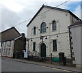
Moriah Aman Christian Centre, Cwmaman
Viewed across Fforchaman Road. Moriah Aman was founded by an independent Welsh chapel in 1843. The chapel was extended to its present architectural form in 1893. The interior remained the same until 1989, when the building was bought by Cwmaman Pentecostal Mission. After mamy years of conversion work, the building was officially reopened in 2001 with a new name, Moriah Aman Christian Centre.
Image: © Jaggery
Taken: 22 Feb 2014
0.05 miles
9
View NW from a former railway bridge in Cwmaman
Viewed from here http://www.geograph.org.uk/photo/3904742 along Cwmneol Street and Spencer Street towards Morris Street.
Image: © Jaggery
Taken: 22 Feb 2014
0.06 miles
10
Milton Street south of the Cwmneol Street junction, Cwmaman
Viewed from the corner of Spencer Street. Cwmneol Street is on the left.
Image: © Jaggery
Taken: 22 Feb 2014
0.06 miles


