IMAGES TAKEN NEAR TO
Aberaman Industrial Estate, ABERDARE, CF44 6DA
Introduction
This page details the photographs taken nearby to Aberaman Industrial Estate, CF44 6DA by members of the Geograph project.
The Geograph project started in 2005 with the aim of publishing, organising and preserving representative images for every square kilometre of Great Britain, Ireland and the Isle of Man.

There are currently over 7.5m images from over14,400 individuals and you can help contribute to the project by visiting https://www.geograph.org.uk
Image Map
Images are licensed for reuse under creativecommons.org/licenses/by-sa/2.0
Notes
- Clicking on the map will re-center to the selected point.
- The higher the marker number, the further away the image location is from the centre of the postcode.
Image Listing (24 Images Found)
Images are licensed for reuse under creativecommons.org/licenses/by-sa/2.0
Image
Details
Distance
2
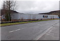
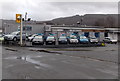
Former Focus in Aberaman Industrial Estate
The 80 metre long disused store is alongside the A4059. Focus DIY was a privately-owned chain of DIY stores. Most had a garden centre. After several years of financial difficulties, the company entered administration in early May 2011. About 50 of its stores were sold to other DIY companies.
The remaining stores, including this one, closed down in the summer of 2011.
Image: © Jaggery
Taken: 19 Feb 2014
0.15 miles
4
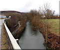
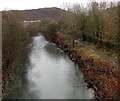
Afon Cynon upstream from the A4059 in Cwmbach
The river flows towards the A4059 bridge west of Cwmbach railway station.
Image: © Jaggery
Taken: 19 Feb 2014
0.18 miles
5
River and track, Cwmbach
The Afon Cynon flows away from the A4059 bridge near Cwmbach railway station.
Image: © Jaggery
Taken: 19 Feb 2014
0.18 miles
6
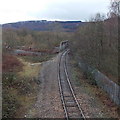
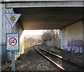
Railway bridge over the Afon Cynon in Cwmbach
South of Cwmbach railway station, on the route to Fernhill station, the single-track line
crosses a bridge over the Afon Cynon. The river is visible on the left side of the bridge.
Image: © Jaggery
Taken: 19 Feb 2014
0.18 miles
7
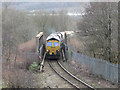
Coal train at Cwmbach
Friday, 24th February 2017 marked the last day of coal-train workings from Tower Colliery to Aberthaw Power Station. The final train of empties was headed by Freightliner Class 66 locomotive No. 66519, and is seen crossing the river just before Cwmbach station.
Image: © Gareth James
Taken: 24 Feb 2017
0.20 miles
8
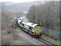
Coal train at Cwmbach
Friday, 24th February 2017 marked the last day of coal-train workings from Tower Colliery to Aberthaw Power Station. The final train of empties was headed by Freightliner Class 66 locomotive No. 66519, and is seen approaching Cwmbach station.
Image: © Gareth James
Taken: 24 Feb 2017
0.20 miles
9
Gerry Hill Car Sales in Cwmbach
One of several vehicle businesses alongside the A4059 at the southern edge of the village near Aberdare.
Image: © Jaggery
Taken: 25 Jan 2014
0.22 miles
10
Signs facing Cwmbach railway station
On the left here. https://www.geograph.org.uk/photo/3825755 The upper sign tells train drivers to check that the train's Automatic Warning System (AWS) is working. AWS is a safeguard against a driver failing to respond to a signal or misreading its aspect. If a driver fails to acknowledge an AWS warning within two seconds, brakes are automatically applied. Because this intervention occurs at the distant signal (the caution or amber aspect), AWS will stop the train before it reaches the stop (red) signal. The lower sign states that it is against the law to smoke on this station. The text is also in Welsh.
Image: © Jaggery
Taken: 9 Jan 2019
0.23 miles