IMAGES TAKEN NEAR TO
Jenkin Street, ABERDARE, CF44 6BB
Introduction
This page details the photographs taken nearby to Jenkin Street, CF44 6BB by members of the Geograph project.
The Geograph project started in 2005 with the aim of publishing, organising and preserving representative images for every square kilometre of Great Britain, Ireland and the Isle of Man.

There are currently over 7.5m images from over14,400 individuals and you can help contribute to the project by visiting https://www.geograph.org.uk
Image Map
Images are licensed for reuse under creativecommons.org/licenses/by-sa/2.0
Notes
- Clicking on the map will re-center to the selected point.
- The higher the marker number, the further away the image location is from the centre of the postcode.
Image Listing (42 Images Found)
Images are licensed for reuse under creativecommons.org/licenses/by-sa/2.0
Image
Details
Distance
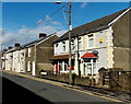
1
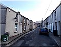
SE along Jenkin Street, Abercwmboi
Viewed from the corner of Mary Street.
Image: © Jaggery
Taken: 22 Feb 2014
0.00 miles
2
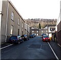
Margaret Street Abercwmboi
Viewed from John Street looking towards Jenkin Street. Bethesda http://www.geograph.org.uk/photo/3860189 is on the left.
Image: © Jaggery
Taken: 22 Feb 2014
0.00 miles
3
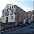
Bethesda Chapel, Abercwmboi
It appears that this building on the corner of John Street and Margaret Street is now in residential use. There were no nameboards here at the February 2014 date of this view, only an inscription in stone on the pediment showing BETHESDA 1864.
UPDATE November 2015. I am grateful to John Samuel who has informed me
that the building is still in use as a regular place of worship.
Image: © Jaggery
Taken: 22 Feb 2014
0.02 miles
4
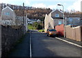
Mary Street, Abercwmboi
Viewed from the John Street end looking towards Jenkin Street.
Image: © Jaggery
Taken: 22 Feb 2014
0.05 miles
5
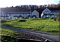
Maple Terrace, Abercwmboi
Houses at the southern edge of the village. Behind the houses is a wood, Coed Abercwmboi.
Image: © Jaggery
Taken: 22 Feb 2014
0.06 miles
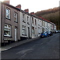
6
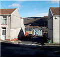
Down Mary Street, Abercwmboi
Viewed across Jenkin Street looking down Mary Street towards John Street.
Image: © Jaggery
Taken: 22 Feb 2014
0.07 miles
7
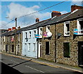
Sold signs in John Street, Abercwmboi
Several SOLD boards were on display in late February 2014.
Image: © Jaggery
Taken: 22 Feb 2014
0.07 miles
8
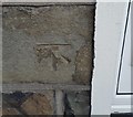
Ordnance Survey Cut Mark
This OS cut mark can be found on No56 John Street. It marks a point 117.580m above mean sea level.
Image: © Adrian Dust
Taken: 19 Jan 2018
0.07 miles
9
John Street from Bronallt Terrace, Abercwmboi
The street name sign opposite the Tanycoed Terrace junction marks the point
where the B4275 Bronallt Terrace on the camera side becomes the B4275 John Street ahead.
Image: © Jaggery
Taken: 22 Feb 2014
0.07 miles
10
Tanycoed Terrace Abercwmboi
Viewed from the corner of the B4275. The street ends at the edge of a wood, Coed Abercwmboi.
Image: © Jaggery
Taken: 22 Feb 2014
0.07 miles