IMAGES TAKEN NEAR TO
Beech Terrace, ABERDARE, CF44 6AN
Introduction
This page details the photographs taken nearby to Beech Terrace, CF44 6AN by members of the Geograph project.
The Geograph project started in 2005 with the aim of publishing, organising and preserving representative images for every square kilometre of Great Britain, Ireland and the Isle of Man.

There are currently over 7.5m images from over14,400 individuals and you can help contribute to the project by visiting https://www.geograph.org.uk
Image Map
Images are licensed for reuse under creativecommons.org/licenses/by-sa/2.0
Notes
- Clicking on the map will re-center to the selected point.
- The higher the marker number, the further away the image location is from the centre of the postcode.
Image Listing (33 Images Found)
Images are licensed for reuse under creativecommons.org/licenses/by-sa/2.0
Image
Details
Distance
1
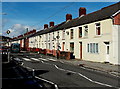
NW along Park View Terrace, Abercwmboi
The B4275 John Street behind the camera becomes the B4275 Park View Terrace ahead.
Image: © Jaggery
Taken: 22 Feb 2014
0.10 miles
2
Wok-U-Like in Abercwmboi
Chinese takeaway at 113 John Street, on the corner of Cromer Street.
Image: © Jaggery
Taken: 22 Feb 2014
0.10 miles
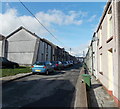
3
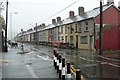
John Street, Abercwmboi
The B4275 through Abercwmboi, is the main street. It is characterised by rows of mining town terraced houses, and these days extensive traffic calming.
Image: © Graham Horn
Taken: 4 Oct 2008
0.10 miles
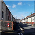
4
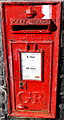
Closeup view of a George V postbox in Abercwmboi
Located here. http://www.geograph.org.uk/photo/3882880
Image: © Jaggery
Taken: 22 Feb 2014
0.11 miles
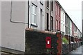
5
George V postbox in a Park View Terrace wall, Abercwmboi
In the wall alongside 88 Park View Terrace. The letters GR on the box date
it to the reign of King George V (1910 to early 1936). http://www.geograph.org.uk/photo/3882885 to a close view.
Image: © Jaggery
Taken: 22 Feb 2014
0.11 miles
6
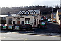
Cap Coch, Abercwmboi
Pub on the south side of John Street. A 19th century map shows that Abercwmboi was named Cap Coch (Red Cap) at that time, though a nearby wood is shown as Coed Abercwmboi and Abercwmboi Colliery was to the east of the residential part of the village.
Image: © Jaggery
Taken: 22 Feb 2014
0.11 miles
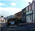
7
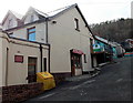
Clarks Carpets, Abercwmboi
The carpet shop is set back from John Street, on the west side of Cap Coch. http://www.geograph.org.uk/photo/3882780
Image: © Jaggery
Taken: 22 Feb 2014
0.11 miles
8
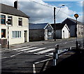
Zebra crossing in Abercwmboi
Across the B4275 Park View Terrace near the corner of Cromer Street.
Although Belisha beacons had marked pedestrian crossings in the UK from 1934, it was not until 1951 that the now familiar black and white stripes stretching across the width of the road were officially introduced. Previously, there were only metal studs across the road surface.
Image: © Jaggery
Taken: 22 Feb 2014
0.11 miles
9
George V postbox, Abercwmboi
This postbox probably conveniently dates this area of housing to the early part of the 20th century.
Image: © Graham Horn
Taken: 4 Oct 2008
0.12 miles
10
Jenkin Street Abercwmboi
Looking NW from the corner of Mary Street towards William Street.
Image: © Jaggery
Taken: 22 Feb 2014
0.12 miles