IMAGES TAKEN NEAR TO
Plas-Newydd Isa, ABERDARE, CF44 0YP
Introduction
This page details the photographs taken nearby to Plas-Newydd Isa, CF44 0YP by members of the Geograph project.
The Geograph project started in 2005 with the aim of publishing, organising and preserving representative images for every square kilometre of Great Britain, Ireland and the Isle of Man.

There are currently over 7.5m images from over14,400 individuals and you can help contribute to the project by visiting https://www.geograph.org.uk
Image Map
Images are licensed for reuse under creativecommons.org/licenses/by-sa/2.0
Notes
- Clicking on the map will re-center to the selected point.
- The higher the marker number, the further away the image location is from the centre of the postcode.
Image Listing (9 Images Found)
Images are licensed for reuse under creativecommons.org/licenses/by-sa/2.0
Image
Details
Distance
1
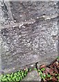
Ordnance Survey Cut Mark
This OS cut mark can be found on the gatepost leading to Plas Newydd. It marks a point 223.367m above mean sea level.
Image: © Adrian Dust
Taken: 5 Jan 2019
0.06 miles
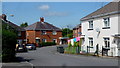
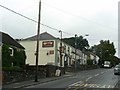
3
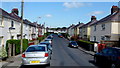
Tre-Ifor, 1
An older-style housing cul-de-sac shaped like a bent key.
Image: © Jonathan Billinger
Taken: 22 Aug 2013
0.09 miles
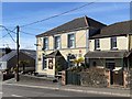
4
Tre-Ifor, 2
An older-style housing cul-de-sac shaped like a bent key.
Image: © Jonathan Billinger
Taken: 22 Aug 2013
0.11 miles
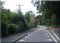
5
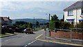
Merthyr Road, Tre-Gibbon
View south-west towards Aberdare from the turning into Tre-Ifor.
Image: © Jonathan Billinger
Taken: 22 Aug 2013
0.11 miles
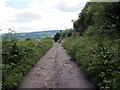
7
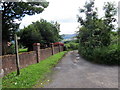
Llwybr yn Nhre-Gibbon / Path in Tre-Gibbon
Llwybr cyhoeddus wrth iddo adael yr heol yn Nhre-Gibbon. Roedd y ffordd yn wreiddiol yn dramffordd lofaol.
A public footpath on leaving the road in Tre-Gibbon. The route was originally a colliery tramway.
Image: © Alan Richards
Taken: 12 Jul 2017
0.20 miles
9
Llwybr Tre-Gibbon / Tre-Gibbon Footpath
Llwybr cyhoeddus yn mynd i gyfeiriad Llwydcoed. Roedd y ffordd yn wreiddiol yn dramffordd lofaol.
A public footpath heading in the direction of Llwydcoed village (trans. grey trees). The route was originally a colliery dramway.
Image: © Alan Richards
Taken: 12 Jul 2017
0.21 miles