IMAGES TAKEN NEAR TO
New Scales Houses, ABERDARE, CF44 0UG
Introduction
This page details the photographs taken nearby to New Scales Houses, CF44 0UG by members of the Geograph project.
The Geograph project started in 2005 with the aim of publishing, organising and preserving representative images for every square kilometre of Great Britain, Ireland and the Isle of Man.

There are currently over 7.5m images from over14,400 individuals and you can help contribute to the project by visiting https://www.geograph.org.uk
Image Map
Images are licensed for reuse under creativecommons.org/licenses/by-sa/2.0
Notes
- Clicking on the map will re-center to the selected point.
- The higher the marker number, the further away the image location is from the centre of the postcode.
Image Listing (33 Images Found)
Images are licensed for reuse under creativecommons.org/licenses/by-sa/2.0
Image
Details
Distance
1
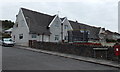
New Scales Houses, Llwydcoed
Located between the B4276 Llwydcoed Road and Kingsbury Court (ahead).
Out of shot, the year 1918 is inscribed on a corner tablet a couple of metres to the right of the postbox. Members of the Scale family were industrialists in this area in the first half of the 19th century.
Image: © Jaggery
Taken: 3 May 2014
0.01 miles
2
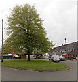
Tree in the middle of Kingsbury Court, Llwydcoed
In early May foliage.
Image: © Jaggery
Taken: 3 May 2014
0.01 miles
3
Kingsbury Court houses, Llwydcoed
Some of the houses arranged in a circle around this http://www.geograph.org.uk/photo/4051301 tree.
Image: © Jaggery
Taken: 3 May 2014
0.03 miles
4
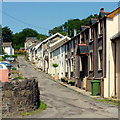
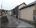
Miner's Row, Llwydcoed
Row of traditional Welsh miner's cottages.
Image: © Jonathan Billinger
Taken: 22 Aug 2013
0.04 miles
5
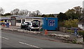
Bubbles in Llwydcoed
Viewed across B4276 Llwydcoed Road. Bubbles Valeting & Car Wash is at the NW end of a trio of businesses. The other two are Second Hand Store and American Diner. http://www.geograph.org.uk/photo/3976336
Image: © Jaggery
Taken: 3 May 2014
0.04 miles
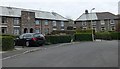
6
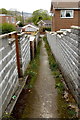
Path from Kingsbury Place to Kingsbury Court, Llwydcoed
About halfway along a 40 metre long path.
Image: © Jaggery
Taken: 3 May 2014
0.04 miles
7
Miners Row, Llwydcoed
Viewed from the B4276 Llwydcoed Road end looking towards Kingsbury Place. Miners Row dates from the early 19th century, houses built as Llwydcoed began to change from a rural to an industrial community.
Image: © Jaggery
Taken: 3 May 2014
0.05 miles
8
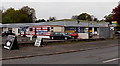
American Diner in Llwydcoed
Viewed across the B4276 Llwydcoed Road. The diner is between a secondhand store http://www.geograph.org.uk/photo/3976324 on the left and a car wash on the right.
Image: © Jaggery
Taken: 3 May 2014
0.05 miles
9
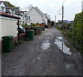
Kingsbury Place puddles, Llwydcoed
A 5 mph speed limit http://www.geograph.org.uk/photo/4051230 applies here.
Image: © Jaggery
Taken: 3 May 2014
0.05 miles
10
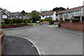
Northern end of Kingsbury Court, Llwydcoed
Road access to Kingsbury Court is from the B4276.
Image: © Jaggery
Taken: 3 May 2014
0.06 miles