IMAGES TAKEN NEAR TO
Kingsbury Place, ABERDARE, CF44 0TR
Introduction
This page details the photographs taken nearby to Kingsbury Place, CF44 0TR by members of the Geograph project.
The Geograph project started in 2005 with the aim of publishing, organising and preserving representative images for every square kilometre of Great Britain, Ireland and the Isle of Man.

There are currently over 7.5m images from over14,400 individuals and you can help contribute to the project by visiting https://www.geograph.org.uk
Image Map
Images are licensed for reuse under creativecommons.org/licenses/by-sa/2.0
Notes
- Clicking on the map will re-center to the selected point.
- The higher the marker number, the further away the image location is from the centre of the postcode.
Image Listing (32 Images Found)
Images are licensed for reuse under creativecommons.org/licenses/by-sa/2.0
Image
Details
Distance
1
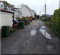
Kingsbury Place puddles, Llwydcoed
A 5 mph speed limit http://www.geograph.org.uk/photo/4051230 applies here.
Image: © Jaggery
Taken: 3 May 2014
0.03 miles
2
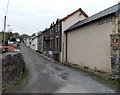
Miners Row, Llwydcoed
Viewed from the B4276 Llwydcoed Road end looking towards Kingsbury Place. Miners Row dates from the early 19th century, houses built as Llwydcoed began to change from a rural to an industrial community.
Image: © Jaggery
Taken: 3 May 2014
0.05 miles
3
Kingsbury Place between fences, Llwydcoed
A 5mph speed limit http://www.geograph.org.uk/photo/4051230 applies here.
Image: © Jaggery
Taken: 3 May 2014
0.05 miles
4
Northern end of Kingsbury Court, Llwydcoed
Road access to Kingsbury Court is from the B4276.
Image: © Jaggery
Taken: 3 May 2014
0.05 miles
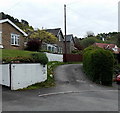
5
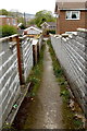
Path from Kingsbury Place to Kingsbury Court, Llwydcoed
About halfway along a 40 metre long path.
Image: © Jaggery
Taken: 3 May 2014
0.05 miles
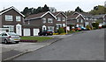
6
Kingsbury Court houses, Llwydcoed
Some of the houses arranged in a circle around this http://www.geograph.org.uk/photo/4051301 tree.
Image: © Jaggery
Taken: 3 May 2014
0.06 miles
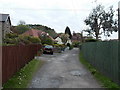
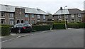
7
Maes-yr-Helyg houses in Llwydcoed
Viewed from the B4276 end.
Image: © Jaggery
Taken: 3 May 2014
0.07 miles
8
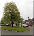
Tree in the middle of Kingsbury Court, Llwydcoed
In early May foliage.
Image: © Jaggery
Taken: 3 May 2014
0.07 miles
9
5 mph speed limit along Kingsbury Place, Llwydcoed
Viewed from the NE end of Church Avenue. On the bend into Kingsbury Place, a notice
shows a 5 mph speed limit and no access to heavy goods vehicles, because of bank damage.
Image: © Jaggery
Taken: 3 May 2014
0.08 miles
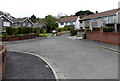
10
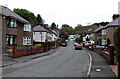
Church Avenue, Llwydcoed
Viewed from the edge of the B4276 looking towards Kingsbury Place.
Image: © Jaggery
Taken: 3 May 2014
0.09 miles