IMAGES TAKEN NEAR TO
Hurst Grove, ABERDARE, CF44 0SE
Introduction
This page details the photographs taken nearby to Hurst Grove, CF44 0SE by members of the Geograph project.
The Geograph project started in 2005 with the aim of publishing, organising and preserving representative images for every square kilometre of Great Britain, Ireland and the Isle of Man.

There are currently over 7.5m images from over14,400 individuals and you can help contribute to the project by visiting https://www.geograph.org.uk
Image Map
Images are licensed for reuse under creativecommons.org/licenses/by-sa/2.0
Notes
- Clicking on the map will re-center to the selected point.
- The higher the marker number, the further away the image location is from the centre of the postcode.
Image Listing (17 Images Found)
Images are licensed for reuse under creativecommons.org/licenses/by-sa/2.0
Image
Details
Distance
1
Hurst Grove, Abernant
A cul-de-sac viewed from the Abernant Road end.
Image: © Jaggery
Taken: 26 Feb 2014
0.02 miles
2
Abernant Road houses, Abernant
Viewed from a side road. http://www.geograph.org.uk/photo/3863834
Image: © Jaggery
Taken: 26 Feb 2014
0.06 miles
3
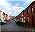
Fothergill Street, Abernant
On the east side of Abernant Road.
Image: © Jaggery
Taken: 26 Feb 2014
0.06 miles
4
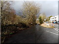
Side road in Abernant
Viewed from the edge of Abernant Road. The side road leads to Moss Row, Moss Place and Little Row.
Image: © Jaggery
Taken: 26 Feb 2014
0.07 miles
5
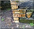
Ordnance Survey Cut Mark
This OS cut mark can be found on the wall south side of Abernant Road. It marks a point 168.225m above mean sea level.
Image: © Adrian Dust
Taken: 2 May 2024
0.07 miles
6
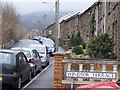
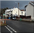
Windsor Terrace, Abernant, near Aberdare
Windsor Terrace, Abernant, near Aberdare.
Image: © Darren W Rees
Taken: 6 Feb 2008
0.08 miles
7
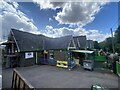
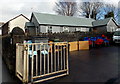
Ysgol Gynradd Abernant
Abernant Junior School.
Image: © Alan Hughes
Taken: 20 Aug 2022
0.08 miles
8
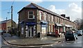
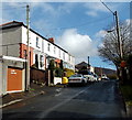
Park View Stores, Abernant
The Lifestyle Express convenience store is on the corner of Fothergill Street on the left and Park View Terrace on the right.
Image: © Jaggery
Taken: 26 Feb 2014
0.09 miles
9
St Matthew's Church, Abernant
Viewed from the entrance to the school next door. St Matthew's Church is in the Church in Wales parish of Aberdare. Affectionately known as a tin church, this corrugated metal building dates from 1888, erected as a mission church in the expectation that it would be in use for about a decade, when it would be replaced by a new, more substantial building. This late February 2014 view, more than a century and a quarter later, shows that it is still in use.
Image: © Jaggery
Taken: 26 Feb 2014
0.09 miles
10
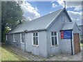
St Matthew Church, Abernant
Clad with corrugated sheeting, this is one of only a handful of tin tabernacles in South Wales.
See https://en.wikipedia.org/wiki/St_Matthew%27s_Church,_Abernant.
See also https://en.wikipedia.org/wiki/Tin_tabernacle.
Image: © Alan Hughes
Taken: 20 Aug 2022
0.09 miles