IMAGES TAKEN NEAR TO
Alexandra Terrace, ABERDARE, CF44 0RG
Introduction
This page details the photographs taken nearby to Alexandra Terrace, CF44 0RG by members of the Geograph project.
The Geograph project started in 2005 with the aim of publishing, organising and preserving representative images for every square kilometre of Great Britain, Ireland and the Isle of Man.

There are currently over 7.5m images from over14,400 individuals and you can help contribute to the project by visiting https://www.geograph.org.uk
Image Map
Images are licensed for reuse under creativecommons.org/licenses/by-sa/2.0
Notes
- Clicking on the map will re-center to the selected point.
- The higher the marker number, the further away the image location is from the centre of the postcode.
Image Listing (134 Images Found)
Images are licensed for reuse under creativecommons.org/licenses/by-sa/2.0
Image
Details
Distance
1
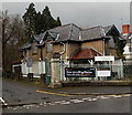
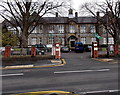
Disused lodge at the entrance to the site of the former Aberdare Hospital
Viewed across Abernant Road. The former lodge has boards protecting its windows.
Aberdare Hospital closed in 2012 after the opening of the purpose-built £82 million Ysbyty Cwm Cynon in Mountain Ash.
Image: © Jaggery
Taken: 26 Feb 2014
0.07 miles
2
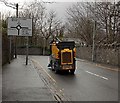
Whizzing to Aberdare
Street cleaning vehicles are usually seen going about their business at a very few mph, so it was a surprise to see this one heading towards the centre of Aberdare along Abernant Road at about 20mph.
Image: © Jaggery
Taken: 26 Feb 2014
0.10 miles
3
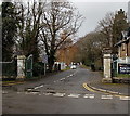
Entrance road to the site of the former Aberdare Hospital
Viewed across Abernant Road. Aberdare Hospital closed in 2012 after
the opening of the purpose-built £82 million Ysbyty Cwm Cynon in Mountain Ash.
Image: © Jaggery
Taken: 26 Feb 2014
0.10 miles
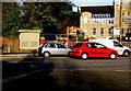
4
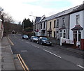
Abernant Road, Aberdare
Viewed from near the roundabout at the Cwmbach Road and Wellington Street roundabout.
Image: © Jaggery
Taken: 4 Feb 2014
0.11 miles
5
Aberdare Girls' School
Viewed across Cwmbach Road. The school is a single-sex comprehensive for pupils aged 11-18.
Image: © Jaggery
Taken: 19 Feb 2014
0.11 miles
6
Fire Station electricity substation, Aberdare
Located on the north side of Cwmbach Road opposite Aberdare Fire Station, the large cabinet is a Western Power Distribution electricity substation. Its identifier is FIRE STATION ABERDARE S/S 551971
Image: © Jaggery
Taken: 9 Jan 2019
0.11 miles
7
Relic of the South Wales Electricity Board, Cwmbach Road, Aberdare
On the left here https://www.geograph.org.uk/photo/6027786 viewed in January 2019. One of twelve Area Boards created under the terms of the Electricity Act 1947 which nationalised the more than 600 electric power companies in the UK, the South Wales Electricity Board was renamed SWALEC (South Wales Electricity) in 1990.
Image: © Jaggery
Taken: 9 Jan 2019
0.12 miles
8
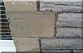
Ordnance Survey Cut Mark
This OS cut mark can be found on the SE face of the school. It marks a point 125.465m above mean sea level.
Image: © Adrian Dust
Taken: 7 Dec 2020
0.12 miles
9

Bilingual temporary signs, Cwmbach Road, Aberdare
Welsh/English signs facing westbound traffic on the approach
to temporary traffic lights at roadworks on January 9th 2019.
Image: © Jaggery
Taken: 9 Jan 2019
0.13 miles
10
Trap Lane, Aberdare
Viewed from the corner of Cwmbach Road. Trap Lane leads to Abernant Road.
Image: © Jaggery
Taken: 9 Jan 2019
0.13 miles