IMAGES TAKEN NEAR TO
Heol Pen Nant, ABERDARE, CF44 0QD
Introduction
This page details the photographs taken nearby to Heol Pen Nant, CF44 0QD by members of the Geograph project.
The Geograph project started in 2005 with the aim of publishing, organising and preserving representative images for every square kilometre of Great Britain, Ireland and the Isle of Man.

There are currently over 7.5m images from over14,400 individuals and you can help contribute to the project by visiting https://www.geograph.org.uk
Image Map
Images are licensed for reuse under creativecommons.org/licenses/by-sa/2.0
Notes
- Clicking on the map will re-center to the selected point.
- The higher the marker number, the further away the image location is from the centre of the postcode.
Image Listing (24 Images Found)
Images are licensed for reuse under creativecommons.org/licenses/by-sa/2.0
Image
Details
Distance
1
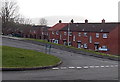
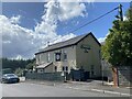
Heol Pen-nant, Abernant, Aberdare
Heol Pen-nant is a row of four houses adjacent to Pant-yr-eos, viewed across Abernant Road.
Image: © Jaggery
Taken: 26 Feb 2014
0.00 miles
2
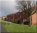
Rhiw Nant, Abernant
A row of houses alongside Abernant Road.
Image: © Jaggery
Taken: 26 Feb 2014
0.02 miles
3
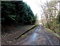
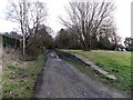
Platform at the site of Abernant railway station, Aberdare
Much of the platform remains in 2014 on the site of Abernant railway station
where passenger services ceased in 1962. The railbed is now a public footpath.
http://www.geograph.org.uk/photo/3016433 to FlyingStag's 1962 photo of a train in the station.
Image: © Jaggery
Taken: 26 Feb 2014
0.03 miles
4
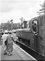
Abernant station
The short branch train from Merthyr Tydfil to Hirwaun pauses at Abernant shortly before closure of the line. Built originally to carry traffic between Merthyr and Neath, in later years passengers had to change at Hirwaun onto a Neath-bound train which had come up the Cynon Valley.
Image: © Flying Stag
Taken: Unknown
0.03 miles
5
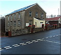
Rhoswenallt Inn
Public house in Abernant.
Image: © Alan Hughes
Taken: 20 Aug 2022
0.03 miles
6
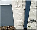
Ordnance Survey Cut Mark
This OS cut mark can be found on the Rhoswenallt PH. It marks a point 195.243m above mean sea level.
Image: © Adrian Dust
Taken: 2 May 2024
0.05 miles
7
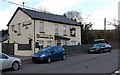
Rhoswenallt Inn, Abernant, Aberdare
Viewed across Abernant Road from the corner of Pant-yr-Eos.
Image: © Jaggery
Taken: 26 Feb 2014
0.05 miles
8
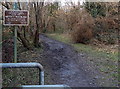
Railway path notice, Abernant, Aberdare
Located alongside the Llwydcoed to Cwmbach railway path following the route of a dismantled railway near the site of the former Abernant station where a platform remains. http://www.geograph.org.uk/photo/3999418
Image: © Jaggery
Taken: 26 Feb 2014
0.05 miles
9
Bethel Baptist Chapel, Abernant
Viewed across Abernant Road. The inscription in Welsh on the building shows that it was built in 1856, enlarged in 1862 and 1895.
Image: © Jaggery
Taken: 26 Feb 2014
0.05 miles
10
NW end of a former railway station platform, Abernant, Aberdare
The rest of Abernant railway station, where passenger services ceased in 1962, has been demolished, leaving only this platform, alongside what is now a public footpath.
http://www.geograph.org.uk/photo/3016433 to Flying Stag's 1962 photo of a train in the station.
Image: © Jaggery
Taken: 26 Feb 2014
0.07 miles