IMAGES TAKEN NEAR TO
College Gardens, ABERDARE, CF44 0PZ
Introduction
This page details the photographs taken nearby to College Gardens, CF44 0PZ by members of the Geograph project.
The Geograph project started in 2005 with the aim of publishing, organising and preserving representative images for every square kilometre of Great Britain, Ireland and the Isle of Man.

There are currently over 7.5m images from over14,400 individuals and you can help contribute to the project by visiting https://www.geograph.org.uk
Image Map
Images are licensed for reuse under creativecommons.org/licenses/by-sa/2.0
Notes
- Clicking on the map will re-center to the selected point.
- The higher the marker number, the further away the image location is from the centre of the postcode.
Image Listing (62 Images Found)
Images are licensed for reuse under creativecommons.org/licenses/by-sa/2.0
Image
Details
Distance
1
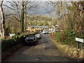
Forge Trip leading to Office Houses, Abernant
Viewed from the corner of Abernant Road.
Image: © Jaggery
Taken: 26 Feb 2014
0.09 miles
2
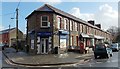
Park View Stores, Abernant
The Lifestyle Express convenience store is on the corner of Fothergill Street on the left and Park View Terrace on the right.
Image: © Jaggery
Taken: 26 Feb 2014
0.11 miles
3
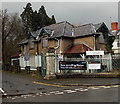
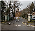
Disused lodge at the entrance to the site of the former Aberdare Hospital
Viewed across Abernant Road. The former lodge has boards protecting its windows.
Aberdare Hospital closed in 2012 after the opening of the purpose-built £82 million Ysbyty Cwm Cynon in Mountain Ash.
Image: © Jaggery
Taken: 26 Feb 2014
0.12 miles
4
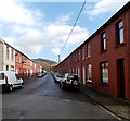
Fothergill Street, Abernant
On the east side of Abernant Road.
Image: © Jaggery
Taken: 26 Feb 2014
0.14 miles
5
Entrance road to the site of the former Aberdare Hospital
Viewed across Abernant Road. Aberdare Hospital closed in 2012 after
the opening of the purpose-built £82 million Ysbyty Cwm Cynon in Mountain Ash.
Image: © Jaggery
Taken: 26 Feb 2014
0.15 miles
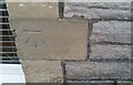
6
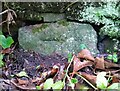
Ordnance Survey Cut Mark
This slightly covered OS cut mark can be found on the wall south side of the lane. It marks a point 147.325m above mean sea level.
Image: © Adrian Dust
Taken: 7 Dec 2020
0.15 miles
7
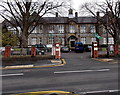
Aberdare Girls' School
Viewed across Cwmbach Road. The school is a single-sex comprehensive for pupils aged 11-18.
Image: © Jaggery
Taken: 19 Feb 2014
0.16 miles
8
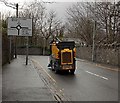
Whizzing to Aberdare
Street cleaning vehicles are usually seen going about their business at a very few mph, so it was a surprise to see this one heading towards the centre of Aberdare along Abernant Road at about 20mph.
Image: © Jaggery
Taken: 26 Feb 2014
0.16 miles
9
Ordnance Survey Cut Mark
This OS cut mark can be found on the SE face of the school. It marks a point 125.465m above mean sea level.
Image: © Adrian Dust
Taken: 7 Dec 2020
0.17 miles
10
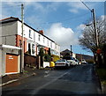
Hurst Grove, Abernant
A cul-de-sac viewed from the Abernant Road end.
Image: © Jaggery
Taken: 26 Feb 2014
0.17 miles