IMAGES TAKEN NEAR TO
ABERDARE, CF44 0NN
Introduction
This page details the photographs taken nearby to CF44 0NN by members of the Geograph project.
The Geograph project started in 2005 with the aim of publishing, organising and preserving representative images for every square kilometre of Great Britain, Ireland and the Isle of Man.

There are currently over 7.5m images from over14,400 individuals and you can help contribute to the project by visiting https://www.geograph.org.uk
Image Map
Images are licensed for reuse under creativecommons.org/licenses/by-sa/2.0
Notes
- Clicking on the map will re-center to the selected point.
- The higher the marker number, the further away the image location is from the centre of the postcode.
Image Listing (194 Images Found)
Images are licensed for reuse under creativecommons.org/licenses/by-sa/2.0
Image
Details
Distance
1
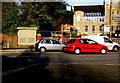
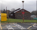
Fire Station electricity substation, Aberdare
Located on the north side of Cwmbach Road opposite Aberdare Fire Station, the large cabinet is a Western Power Distribution electricity substation. Its identifier is FIRE STATION ABERDARE S/S 551971
Image: © Jaggery
Taken: 9 Jan 2019
0.01 miles
2
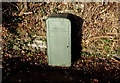
Relic of the South Wales Electricity Board, Cwmbach Road, Aberdare
On the left here https://www.geograph.org.uk/photo/6027786 viewed in January 2019. One of twelve Area Boards created under the terms of the Electricity Act 1947 which nationalised the more than 600 electric power companies in the UK, the South Wales Electricity Board was renamed SWALEC (South Wales Electricity) in 1990.
Image: © Jaggery
Taken: 9 Jan 2019
0.01 miles
3
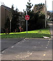
Fire Station - No Parking, Cwmbach Road, Aberdare
The sign is near Aberdare Fire & Rescue Station. https://www.geograph.org.uk/photo/6342191
Image: © Jaggery
Taken: 9 Jan 2019
0.02 miles
4

Bilingual temporary signs, Cwmbach Road, Aberdare
Welsh/English signs facing westbound traffic on the approach
to temporary traffic lights at roadworks on January 9th 2019.
Image: © Jaggery
Taken: 9 Jan 2019
0.03 miles
5
Aberdare Girls' School
Viewed across Cwmbach Road. The school is a single-sex comprehensive for pupils aged 11-18.
Image: © Jaggery
Taken: 19 Feb 2014
0.04 miles
6
Kingdom Hall in Aberdare
The Kingdom Hall Of Jehovah's Witnesses is in Cwmbach Road, viewed across the entrance to Aberdare Fire Station. http://www.geograph.org.uk/photo/3854533 Jehovah's Witnesses use Kingdom Hall to describe their places of worship because the biblical use of "church" usually refers to the congregation of people rather than a structure.
Image: © Jaggery
Taken: 19 Feb 2014
0.04 miles
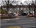
7
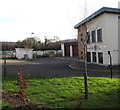
Aberdare Fire & Rescue Station
Part of the South Wales Fire & Rescue Service, set back from the south side of Cwmbach Road. The fire station has been on this site since 1967. In addition to the town of Aberdare, the station provides fire & rescue cover for neighbouring towns and villages (Abercwmboi, Cwmaman, Cwmbach, Cwmdare, Llwydcoed, Mountain Ash, Penrhiwceiber, Penywaun, Trecynon).
Image: © Jaggery
Taken: 9 Jan 2019
0.04 miles
8
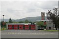
Aberdare Fire Station
Aberdare Fire Station, Cwmbach Road, Aberdare is part of the South Wales Fire & Rescue Service
Image: © Kevin Hale
Taken: 4 Jun 2007
0.05 miles
9
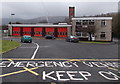
Aberdare Fire Station
Set back 40 metres from the south side of Cwmbach Road, part of the South Wales Fire & Rescue Service. The fire station has been on this site since 1967. In addition to the town of Aberdare, the station provides fire cover for neighbouring towns and villages (Abercwmboi, Cwmaman, Cwmbach, Cwmdare, Llwydcoed, Mountain Ash, Penrhiwceiber, Penywaun and Trecynon).
Image: © Jaggery
Taken: 19 Feb 2014
0.05 miles
10
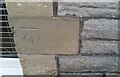
Ordnance Survey Cut Mark
This OS cut mark can be found on the SE face of the school. It marks a point 125.465m above mean sea level.
Image: © Adrian Dust
Taken: 7 Dec 2020
0.05 miles