IMAGES TAKEN NEAR TO
Penderyn, ABERDARE, CF44 0NJ
Introduction
This page details the photographs taken nearby to CF44 0NJ by members of the Geograph project.
The Geograph project started in 2005 with the aim of publishing, organising and preserving representative images for every square kilometre of Great Britain, Ireland and the Isle of Man.

There are currently over 7.5m images from over14,400 individuals and you can help contribute to the project by visiting https://www.geograph.org.uk
Image Map
Images are licensed for reuse under creativecommons.org/licenses/by-sa/2.0
Notes
- Clicking on the map will re-center to the selected point.
- The higher the marker number, the further away the image location is from the centre of the postcode.
Image Listing (3 Images Found)
Images are licensed for reuse under creativecommons.org/licenses/by-sa/2.0
Image
Details
Distance
1
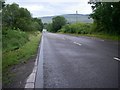
The road to Hirwaun
The A4069 running south from Penderyn coincidentally runs along the line of an ancient NNW-SSE trending geological fault which throws the rocks strata down to the west though there is no sign of it at the surface hereabouts, the ground being smeared with glacial till to a depth. The ridge in the distance is that of the north-facing Pennant scarp which during the Ice Age/s formed a considerable barrier to ice moving south from the Brecon Beacons and in fact generated a few small glaciers of its own.
Image: © Alan Bowring
Taken: 7 Aug 2008
0.08 miles
2
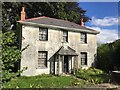
Derelict Lodge
Derelict lodge at entrance to Ty Newydd.
Image: © Alan Hughes
Taken: 17 Sep 2016
0.14 miles