IMAGES TAKEN NEAR TO
Claerwen Close, ABERDARE, CF44 0LQ
Introduction
This page details the photographs taken nearby to Claerwen Close, CF44 0LQ by members of the Geograph project.
The Geograph project started in 2005 with the aim of publishing, organising and preserving representative images for every square kilometre of Great Britain, Ireland and the Isle of Man.

There are currently over 7.5m images from over14,400 individuals and you can help contribute to the project by visiting https://www.geograph.org.uk
Image Map
Images are licensed for reuse under creativecommons.org/licenses/by-sa/2.0
Notes
- Clicking on the map will re-center to the selected point.
- The higher the marker number, the further away the image location is from the centre of the postcode.
Image Listing (3 Images Found)
Images are licensed for reuse under creativecommons.org/licenses/by-sa/2.0
Image
Details
Distance
2
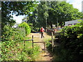
Hen ddramffordd / Former tramline
Cerddwyr yn dilyn llwybr cyhoeddus a fu'n gynt yn ddramffordd a gludai lo o Lofa'r Werfa.
Walker following a public footpath that was formerly a tramline that transported coal from Werfa Colliery (trans. shaded place).
Image: © Alan Richards
Taken: 21 Jul 2018
0.09 miles
3
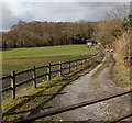
Track NW from Blaennantygroes Road, Cwmbach
The track heads towards farm buildings and trees at the edge of a stream, Nant y Groes.
Image: © Jaggery
Taken: 26 Feb 2014
0.25 miles