IMAGES TAKEN NEAR TO
Llwydcoed, ABERDARE, CF44 0DX
Introduction
This page details the photographs taken nearby to CF44 0DX by members of the Geograph project.
The Geograph project started in 2005 with the aim of publishing, organising and preserving representative images for every square kilometre of Great Britain, Ireland and the Isle of Man.

There are currently over 7.5m images from over14,400 individuals and you can help contribute to the project by visiting https://www.geograph.org.uk
Image Map
Images are licensed for reuse under creativecommons.org/licenses/by-sa/2.0
Notes
- Clicking on the map will re-center to the selected point.
- The higher the marker number, the further away the image location is from the centre of the postcode.
Image Listing (4 Images Found)
Images are licensed for reuse under creativecommons.org/licenses/by-sa/2.0
Image
Details
Distance
1
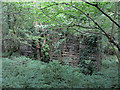
Remains of a railway viaduct near Aberdare
Image: © Gareth James
Taken: 30 Jul 2017
0.19 miles
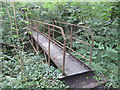
2
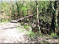
Pontdroed Nant Hir / Nant Hir Footbridge
Pontdroed yn rhychwantu Nant Hir.
A footbridge spanning Nant Hir (trans. long stream).
Image: © Alan Richards
Taken: 22 Apr 2017
0.20 miles
4
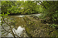
Remains of Weir
Remains of Weir across Afon Cynon
Image: © Nick Earl
Taken: 5 Sep 2009
0.22 miles