IMAGES TAKEN NEAR TO
Rhodfa'r Derw, ABERDARE, CF44 0BZ
Introduction
This page details the photographs taken nearby to Rhodfa'r Derw, CF44 0BZ by members of the Geograph project.
The Geograph project started in 2005 with the aim of publishing, organising and preserving representative images for every square kilometre of Great Britain, Ireland and the Isle of Man.

There are currently over 7.5m images from over14,400 individuals and you can help contribute to the project by visiting https://www.geograph.org.uk
Image Map
Images are licensed for reuse under creativecommons.org/licenses/by-sa/2.0
Notes
- Clicking on the map will re-center to the selected point.
- The higher the marker number, the further away the image location is from the centre of the postcode.
Image Listing (30 Images Found)
Images are licensed for reuse under creativecommons.org/licenses/by-sa/2.0
Image
Details
Distance
1
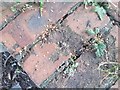
Ordnance Survey Rivet
This OS rivet can be found on the culvert NE side of the road. It marks a point 118.256m above mean sea level.
Image: © Adrian Dust
Taken: 26 Aug 2019
0.08 miles
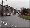
3
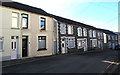
Well Place houses, Cwmbach
On the south side of Well Place. The grey railings are opposite Ynyscynon Street. https://www.geograph.org.uk/photo/3953637
Image: © Jaggery
Taken: 9 Jan 2019
0.14 miles
4
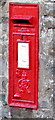
King George VI postbox in a Well Place wall, Cwmbach
Located here. https://www.geograph.org.uk/photo/6028250 King George VI reigned from December 11th 1936 to February 6th 1952.
Image: © Jaggery
Taken: 9 Jan 2019
0.14 miles
5
Postbox in a stone wall, Well Place, Cwmbach
The red box is from the reign of King George VI. https://www.geograph.org.uk/photo/6028253
Image: © Jaggery
Taken: 9 Jan 2019
0.14 miles
6
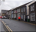
Postman and Royal Mail van in Cwmbach Road, Cwmbach
After making a delivery to a house in Cwmbach Road, a postman wearing an orange dayglo
jacket walks back towards the Royal Mail van at the left edge of the view.
Image: © Jaggery
Taken: 19 Feb 2014
0.14 miles
7
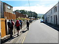
Cerddwyr ar Heol Cwmbach / Walkers on Cwmbach Road
Cerddwyr yn rhodio ar hyd Heol Cwmbach wrth iddynt ddilyn Ffordd Coed Morgannwg.
Walkers strolling along Cwmbach Road (trans. little valley) while following Coed Morgannwg Way.
Image: © Alan Richards
Taken: 21 Jul 2018
0.14 miles
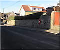
8
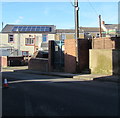
Ynyscynon electricity substation, Cwmbach
The Western Power Distribution electricity substation is in a brick enclosure on the north side of Well Place near the corner of Ynyscynon Street. https://www.geograph.org.uk/photo/3953637 The substation identifier is YNYSCYNON S/S 552256
Image: © Jaggery
Taken: 9 Jan 2019
0.15 miles