1
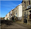
Sion Terrace church and houses, Cwmbach
Cornerstone Church https://www.geograph.org.uk/photo/6028132 is on the right.
Image: © Jaggery
Taken: 9 Jan 2019
0.02 miles
2
Welsh inscription on the former Ebenezer chapel, Cwmbach
Located below the round window here https://www.geograph.org.uk/photo/6028132 on Cornerstone Church, the plaque records that the building is the 1908 renovation of Ebenezer Calvinistic Methodist Chapel built in 1864.
Image: © Jaggery
Taken: 9 Jan 2019
0.02 miles
3
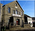
Cornerstone Church, Sion Terrace, Cwmbach
In January 2019 Cornerstone Church is part of the Elim family of churches. The inscription https://www.geograph.org.uk/photo/6028141 in Welsh on the tablet below the round window records that the building is the 1908 renovation of Ebenezer Calvinistic Methodist Chapel built in 1864.
Image: © Jaggery
Taken: 9 Jan 2019
0.02 miles
4
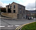
Cornerstone Church, Cwmbach
The building in Sion Terrace was formerly Ebenezer chapel.
Cwmbach Communities First is on the right.
Image: © Jaggery
Taken: 26 Feb 2014
0.02 miles
5
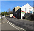
Crown Row, Cwmbach
This is the northern half of Crown Row, viewed from Tirfounder Road.
Image: © Jaggery
Taken: 26 Feb 2014
0.04 miles
6
Down Bridge Road, Cwmbach
Looking south down Bridge Road from the corner of Bethania Place.
The cars are parked alongside the Queen Victoria pub. http://www.geograph.org.uk/photo/3864141
Image: © Jaggery
Taken: 26 Feb 2014
0.04 miles
7
Junction of Tre Telynog and Bridge Road, Cwmbach
From the left, Tre Telynog joins Bridge Road. The Queen Victoria pub https://www.geograph.org.uk/photo/6020471 is on the right.
Image: © Jaggery
Taken: 9 Jan 2019
0.04 miles
8
Tre Telynog flats, Cwmbach
Flats in the SE corner of Tre Telynog, viewed across Bridge Road. A plaque on the wall behind the car commemorates the founding of the first Co-operative Society shop in Wales on this site in 1860.
Image: © Jaggery
Taken: 26 Feb 2014
0.04 miles
9
Ordnance Survey Cut Mark
This OS cut mark can be found on the Queen Victoria PH. It marks a point 127.501m above mean sea level.
Image: © Adrian Dust
Taken: 26 Aug 2019
0.05 miles
10
Queen Victoria in Cwmbach
Pub on the east side of Bridge Road.
Image: © Jaggery
Taken: 9 Jan 2019
0.05 miles


