IMAGES TAKEN NEAR TO
Bridge Road, ABERDARE, CF44 0AL
Introduction
This page details the photographs taken nearby to Bridge Road, CF44 0AL by members of the Geograph project.
The Geograph project started in 2005 with the aim of publishing, organising and preserving representative images for every square kilometre of Great Britain, Ireland and the Isle of Man.

There are currently over 7.5m images from over14,400 individuals and you can help contribute to the project by visiting https://www.geograph.org.uk
Image Map
Images are licensed for reuse under creativecommons.org/licenses/by-sa/2.0
Notes
- Clicking on the map will re-center to the selected point.
- The higher the marker number, the further away the image location is from the centre of the postcode.
Image Listing (81 Images Found)
Images are licensed for reuse under creativecommons.org/licenses/by-sa/2.0
Image
Details
Distance
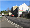
1
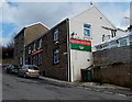
Queen Victoria, Cwmbach
Pub viewed across Bridge Road.
Image: © Jaggery
Taken: 26 Feb 2014
0.01 miles
2
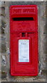
Queen Elizabeth II postbox in the wall of the Queen Victoria, Cwmbach
On the right here. https://www.geograph.org.uk/photo/6020471
Image: © Jaggery
Taken: 9 Jan 2019
0.02 miles
3
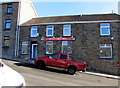
Queen Victoria in Cwmbach
Pub on the east side of Bridge Road.
Image: © Jaggery
Taken: 9 Jan 2019
0.02 miles
4
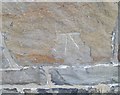
Ordnance Survey Cut Mark
This OS cut mark can be found on the Queen Victoria PH. It marks a point 127.501m above mean sea level.
Image: © Adrian Dust
Taken: 26 Aug 2019
0.03 miles
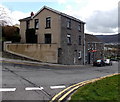
5
Junction of Tre Telynog and Bridge Road, Cwmbach
From the left, Tre Telynog joins Bridge Road. The Queen Victoria pub https://www.geograph.org.uk/photo/6020471 is on the right.
Image: © Jaggery
Taken: 9 Jan 2019
0.03 miles
6
Down Bridge Road, Cwmbach
Looking south down Bridge Road from the corner of Bethania Place.
The cars are parked alongside the Queen Victoria pub. http://www.geograph.org.uk/photo/3864141
Image: © Jaggery
Taken: 26 Feb 2014
0.03 miles
7
Tre Telynog flats, Cwmbach
Flats in the SE corner of Tre Telynog, viewed across Bridge Road. A plaque on the wall behind the car commemorates the founding of the first Co-operative Society shop in Wales on this site in 1860.
Image: © Jaggery
Taken: 26 Feb 2014
0.04 miles
8
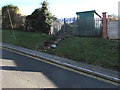
Western Power Distribution electricity substation above Bridge Road, Cwmbach
In a fenced compound accessed by steps. The substation identifier is CAPEL BETHANIA S/S 552250.
Image: © Jaggery
Taken: 9 Jan 2019
0.04 miles
9
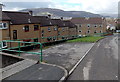
Bethania Place, Cwmbach
Flats in Tre Telynog are on the south side of Bethania Place.
Image: © Jaggery
Taken: 26 Feb 2014
0.04 miles
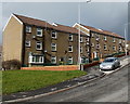
10
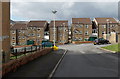
Tre Telynog flats, Cwmbach
The flats are in 3-storey buildings between Bridge Road on the camera side and Bethania Place.
Image: © Jaggery
Taken: 26 Feb 2014
0.04 miles