IMAGES TAKEN NEAR TO
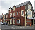
CF4 3LG
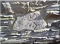
Introduction
This page details the photographs taken nearby to CF4 3LG by members of the Geograph project.
The Geograph project started in 2005 with the aim of publishing, organising and preserving representative images for every square kilometre of Great Britain, Ireland and the Isle of Man.

There are currently over 7.5m images from over14,400 individuals and you can help contribute to the project by visiting https://www.geograph.org.uk
Image Map
Images are licensed for reuse under creativecommons.org/licenses/by-sa/2.0
Notes
- Clicking on the map will re-center to the selected point.
- The higher the marker number, the further away the image location is from the centre of the postcode.
Image Listing (73 Images Found)
Images are licensed for reuse under creativecommons.org/licenses/by-sa/2.0
Image
Details
Distance
1
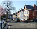
Africa Gardens, Cardiff
Houses on the NE side of the residential road named Africa Gardens, viewed from the corner of Australia Road. In the distance is Newfoundland Road.
Image: © Jaggery
Taken: 23 Mar 2011
0.00 miles
2
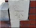
Ordnance Survey Cut Mark
This OS cut mark can be found on No49 Africa Gardens. It marks a point 31.888m above mean sea level.
Image: © Adrian Dust
Taken: 16 Mar 2018
0.02 miles
3
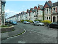
Heathfield Rd, Cardiff
Jubilee bunting still in place.
Image: © John Lord
Taken: 8 Jul 2012
0.07 miles
4
Ordnance Survey Cut Mark
This OS cut mark can be found on the old Sunday School, North Road. It marks a point 29.663m above mean sea level.
Image: © Adrian Dust
Taken: 16 Mar 2018
0.11 miles
5
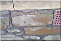
Ordnance Survey Cut Mark
This OS cut mark can be found on the rear of No43 Whitchurch Road. It marks a point 31.148m above mean sea level.
Image: © Adrian Dust
Taken: 16 Mar 2018
0.12 miles
6
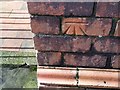
Ordnance Survey Cut Mark
This OS cut mark can be found on the dividing wall between Nos.3 & 5 Africa Gardens. It marks a point 30.486m above mean sea level.
Image: © Adrian Dust
Taken: 16 Mar 2018
0.12 miles
7
Heath Evangelical Church church hall, Cardiff
The church hall is in Llanishen Street. The church is nearby. http://www.geograph.org.uk/photo/1471710
Image: © Jaggery
Taken: 15 Jul 2010
0.12 miles
8
Western end of Llanishen Street, Cardiff
Viewed across Whitchurch Road, the western end of Llanishen Street is now blocked off by railings, a pavement and trees. The other end of the street connects with Allensbank Road.
Image: © Jaggery
Taken: 3 Sep 2009
0.12 miles
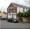
9
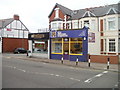
St Joseph's Catholic Sports & Social Club, Cardiff
Located at 29 Whitchurch Road, on the corner of Australia Road.
Image: © Jaggery
Taken: 14 Apr 2010
0.12 miles
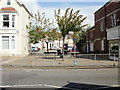
10
Corner of Whitchurch Road and Sachville Avenue, Cardiff
Viewed across Whitchurch Road. Nearest the camera are The Property Megastore and The Life Lounge, Allnations Church. On the other side of Sachville Avenue is BGS Plumbing Supplies.
Image: © Jaggery
Taken: 4 Apr 2011
0.12 miles