IMAGES TAKEN NEAR TO
Blaenllechau, FERNDALE, CF43 4UF
Introduction
This page details the photographs taken nearby to CF43 4UF by members of the Geograph project.
The Geograph project started in 2005 with the aim of publishing, organising and preserving representative images for every square kilometre of Great Britain, Ireland and the Isle of Man.

There are currently over 7.5m images from over14,400 individuals and you can help contribute to the project by visiting https://www.geograph.org.uk
Image Map
Images are licensed for reuse under creativecommons.org/licenses/by-sa/2.0
Notes
- Clicking on the map will re-center to the selected point.
- The higher the marker number, the further away the image location is from the centre of the postcode.
Image Listing (4 Images Found)
Images are licensed for reuse under creativecommons.org/licenses/by-sa/2.0
Image
Details
Distance
1
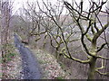
Path on a ledge near Ferndale
The path was once a tramway that run down the hillside to Ferndale Colliery.
Image: © Gareth James
Taken: 4 Apr 2015
0.17 miles
2
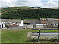
Bench with a view, Ferndale
The bench is in a 25 metre long grassy strip in a gap in the A4233 Duffryn Street houses.
The view is towards a transmitter mast on high ground about 800 metres away.
Image: © Jaggery
Taken: 8 Aug 2013
0.18 miles
3
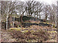
Ruined building in Cwm Rhondda Fach
Given its proximity to the quarry and a tramway, it's high likely this was once a stone processing building.
Image: © Gareth James
Taken: 4 Apr 2015
0.24 miles
4
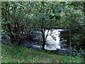
White water in the Rhondda Fach near Ferndale
Viewed from a track and National Cycle Network route 881 from Tylorstown.
Image: © Jaggery
Taken: 20 Aug 2013
0.24 miles