IMAGES TAKEN NEAR TO
Oakland Terrace, FERNDALE, CF43 4UD
Introduction
This page details the photographs taken nearby to Oakland Terrace, CF43 4UD by members of the Geograph project.
The Geograph project started in 2005 with the aim of publishing, organising and preserving representative images for every square kilometre of Great Britain, Ireland and the Isle of Man.

There are currently over 7.5m images from over14,400 individuals and you can help contribute to the project by visiting https://www.geograph.org.uk
Image Map
Images are licensed for reuse under creativecommons.org/licenses/by-sa/2.0
Notes
- Clicking on the map will re-center to the selected point.
- The higher the marker number, the further away the image location is from the centre of the postcode.
Image Listing (42 Images Found)
Images are licensed for reuse under creativecommons.org/licenses/by-sa/2.0
Image
Details
Distance
1
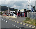
Hand Car Wash & Valeting Service, Ferndale
Viewed across the A4233 Oakland Terrace. The business of the left side
of the car wash is Lockyer & Peacey, leather and fabric sofas.
Image: © Jaggery
Taken: 8 Aug 2013
0.02 miles
2
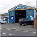
Ferndale Motors, Ferndale
On the corner of the A4233 Oakland Terrace and New Street.
Image: © Jaggery
Taken: 8 Aug 2013
0.02 miles
3
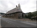
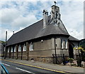
Formerly Our Lady of Penrhys Church, now dwellings
Image: © John Lord
Taken: 20 Jul 2016
0.05 miles
4
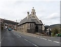
Grade II listed former Roman Catholic church, Ferndale
Now disused, the building retains the name board showing Our Lady of Penrhys, Ferndale.
The location is the corner of the A4233 Oakland Terrace and New Street.
Built in 1912 as a Roman Catholic church in an arts and crafts gothic style, grade II listed in 1996.
Image: © Jaggery
Taken: 8 Aug 2013
0.05 miles
5
Former Roman Catholic Church, Ferndale
Image: © Roger Cornfoot
Taken: 3 Apr 2017
0.06 miles
6
Formerly Our Lady of Penrhys Church, now dwellings
Image: © John Lord
Taken: 20 Jul 2016
0.06 miles
7
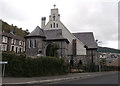
South side of a Grade II listed former Roman Catholic church, Ferndale
Viewed across the A4233 Oakland Terrace. Now disused, the building retains the name board showing Our Lady of Penrhys, Ferndale. Built in 1912 as a Roman Catholic church in an arts and crafts gothic style, grade II listed in 1996.
Image: © Jaggery
Taken: 8 Aug 2013
0.06 miles
8
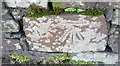
Ordnance Survey Cut Mark
This OS cut mark can be found on the wall SW side of East Road. It marks a point 220.637m above mean sea level.
Image: © Adrian Dust
Taken: 18 Jun 2017
0.07 miles
9
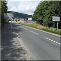
SE boundary of Ferndale
The A4233 reaches Ferndale, a small town located in the county borough of Rhondda Cynon Taf.
The Tylorstown boundary signs http://www.geograph.org.uk/photo/3589356 are on the back of these signs.
Image: © Jaggery
Taken: 8 Aug 2013
0.08 miles
10
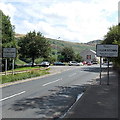
NW boundary of Tylorstown
The A4233 from Ferndale reaches Tylorstown, a village in the county borough of Rhondda Cynon Taf. The Ferndale boundary signs http://www.geograph.org.uk/photo/3589347 are on the back of these signs.
Image: © Jaggery
Taken: 8 Aug 2013
0.08 miles