IMAGES TAKEN NEAR TO
Baptist Square, FERNDALE, CF43 4NT
Introduction
This page details the photographs taken nearby to Baptist Square, CF43 4NT by members of the Geograph project.
The Geograph project started in 2005 with the aim of publishing, organising and preserving representative images for every square kilometre of Great Britain, Ireland and the Isle of Man.

There are currently over 7.5m images from over14,400 individuals and you can help contribute to the project by visiting https://www.geograph.org.uk
Image Map
Images are licensed for reuse under creativecommons.org/licenses/by-sa/2.0
Notes
- Clicking on the map will re-center to the selected point.
- The higher the marker number, the further away the image location is from the centre of the postcode.
Image Listing (8 Images Found)
Images are licensed for reuse under creativecommons.org/licenses/by-sa/2.0
Image
Details
Distance
1
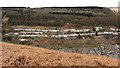
View to Blaenllechau from hillside above Ferndale
Image: © Gareth James
Taken: 4 Apr 2015
0.08 miles
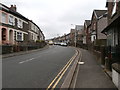
2
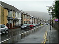
North Road, Ferndale
This is the A4233, the main road through this mining town with an incongruous name.
Image: © Jonathan Billinger
Taken: 4 Oct 2008
0.19 miles
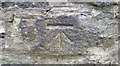
3
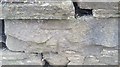
Ordnance Survey Cut Mark
This OS cut mark can be found on the wall south side of North Road. It marks a point 267.837m above mean sea level.
Image: © Adrian Dust
Taken: 16 Jun 2017
0.20 miles
4
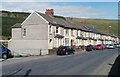
Houses resume, North Road, Ferndale
Behind the camera, two industrial estates and other business premises occupy the north side of the A4233 for about a kilometre. Housing resumes here, close to the right turn for Rhondda Road.
Image: © Jaggery
Taken: 11 May 2011
0.21 miles
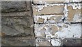
5
Ordnance Survey Cut Mark
This OS cut mark can be found on the wall of No20 Aberdare Road. It marks a point 272.141m above mean sea level.
Image: © Adrian Dust
Taken: 18 Jun 2017
0.23 miles
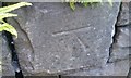
7
Ordnance Survey Cut Mark
This OS cut mark can be found on No151 North Road. It marks a point 256.773m above mean sea level.
Image: © Adrian Dust
Taken: 16 Jun 2017
0.23 miles
8
Ordnance Survey Cut Mark
This OS cut mark can be found on the wall NE side of the lane. It marks a point 248.988m above mean sea level.
Image: © Adrian Dust
Taken: 16 Jun 2017
0.25 miles