IMAGES TAKEN NEAR TO
Rhondda Road, FERNDALE, CF43 4HW

Introduction

This page details the photographs taken nearby to Rhondda Road, CF43 4HW by members of the Geograph project.

The Geograph project started in 2005 with the aim of publishing, organising and preserving representative images for every square kilometre of Great Britain, Ireland and the Isle of Man.

There are currently over 7.5m images from over14,400 individuals and you can help contribute to the project by visiting https://www.geograph.org.uk

Image Map


Images are licensed for reuse under creativecommons.org/licenses/by-sa/2.0
Notes
  • Clicking on the map will re-center to the selected point.
  • The higher the marker number, the further away the image location is from the centre of the postcode.

Image Listing (65 Images Found)

Images are licensed for reuse under creativecommons.org/licenses/by-sa/2.0
  • ...
Image
Details
Distance
1
Ordnance Survey Rivet
This OS rivet can be found on the window sill of the Imperial Club. It marks a point 252.582m above mean sea level.
Image: © Adrian Dust Taken: 16 Jun 2017
0.00 miles
2
Building work, C?r Meibion Morlais Hall, Ferndale
Located on the corner of North Road and Church Street, the hall is home to Côr Meibion Morlais (Morlais Male Choir).
Image: © Jaggery Taken: 11 May 2011
0.05 miles
3
Mosaic outside Ferndale Infants School
Part of a 7-metre long mosaic on the North Road wall of Ferndale Infants School.
Image: © Jaggery Taken: 11 May 2011
0.05 miles
4
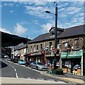
Shops in The Strand, Ferndale
On the right is Dylans Pets & Aquatics. On the left is Village & Valleys Community Shop.
Image: © Jaggery Taken: 20 Aug 2013
0.07 miles
5
View over Maerdy
View towards Mynydd y Ffaldau.
Image: © Alan Hughes Taken: 23 May 2019
0.08 miles
6
The Old Morlais Chapel, Ferndale
Music museum and home of the Morlais Male Choir. https://www.bbc.co.uk/news/uk-wales-15125047
Image: © Alan Hughes Taken: 4 May 2019
0.09 miles
7
C?r Meirion Morlais
Morlais Hall, Ferndale. http://www.cor-meibion-morlais.org.uk/
Image: © Alan Hughes Taken: 4 May 2019
0.09 miles
8
Ordnance Survey Cut Mark
This very badly damaged OS cut mark can be found on No42 Elm Street. It marks a point 246.787m above mean sea level.
Image: © Adrian Dust Taken: 16 Jun 2017
0.09 miles
9
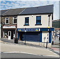
Corner Plaice, Ferndale
Traditional fish & chips shop and cafe at 5 The Strand, on the corner of the A4233 North Road. Some references show "Strand" instead of "The Strand". P & J Carpets (established in 1975) is on the left and number 6 The Strand.
Image: © Jaggery Taken: 20 Aug 2013
0.09 miles
10
Ferndale Old Fire Station
Ferndale Old Fire Station, Lake Street. After the opening of the new Fire Station, Ferndale Old Fire Station was converted and used as an electronics workshop. The new fire station Image looks down on it from higher up the valley. This building was demolished circa 2008 and the site is now an entrance to a car park and boasts a model village created with the help of local school children.
Image: © Kevin Hale Taken: 5 Jun 2007
0.09 miles
  • ...