IMAGES TAKEN NEAR TO
Irfon Terrace, FERNDALE, CF43 4HU
Introduction
This page details the photographs taken nearby to Irfon Terrace, CF43 4HU by members of the Geograph project.
The Geograph project started in 2005 with the aim of publishing, organising and preserving representative images for every square kilometre of Great Britain, Ireland and the Isle of Man.

There are currently over 7.5m images from over14,400 individuals and you can help contribute to the project by visiting https://www.geograph.org.uk
Image Map
Images are licensed for reuse under creativecommons.org/licenses/by-sa/2.0
Notes
- Clicking on the map will re-center to the selected point.
- The higher the marker number, the further away the image location is from the centre of the postcode.
Image Listing (58 Images Found)
Images are licensed for reuse under creativecommons.org/licenses/by-sa/2.0
Image
Details
Distance
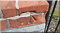
1
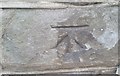
Ordnance Survey Cut Mark
This OS cut mark can be found on No29 Union Street. It marks a point 240.774m above mean sea level.
Image: © Adrian Dust
Taken: 16 Jun 2017
0.04 miles
2
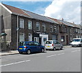
Funk'd Up Barbers, Ferndale
Barber shop at 30 Duffryn Street.
Image: © Jaggery
Taken: 8 Aug 2013
0.06 miles
3
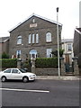
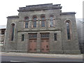
Capel Salem Newydd, Ferndale
Former Welsh Baptist chapel.
Image: © John Lord
Taken: 20 Jul 2016
0.06 miles
4
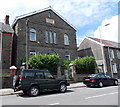
Former Salem Newydd Welsh Baptist Chapel, Ferndale
The former chapel, which closed down in 1994, has been converted to residential use.
The date stone shows the year 1877.
Image: © Jaggery
Taken: 8 Aug 2013
0.07 miles
5
Capel Penuel, Ferndale
Welsh Calvinistic Methodist chapel.
Image: © John Lord
Taken: 20 Jul 2016
0.07 miles
6
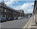
Duffryn Street north of The Ferndale, Ferndale
Viewed from near The Ferndale http://www.geograph.org.uk/photo/3589652
The large building between houses on the left is a converted former chapel. http://www.geograph.org.uk/photo/3589739
Image: © Jaggery
Taken: 8 Aug 2013
0.07 miles
7
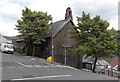
Regent Street side of St Dunstan's Church, Ferndale
Viewed across Ayron Street towards a van parked in Regent Street. The church is part of the Church in Wales parish of Rhondda Fach Uchaf in the Diocese of Llandaff.
Image: © Jaggery
Taken: 8 Aug 2013
0.07 miles
8
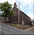
St Dunstan's Church viewed from the SE, Ferndale
Viewed across Ayron Street. The church is part of the Church in Wales
parish of Rhondda Fach Uchaf in the Diocese of Llandaff.
Image: © Jaggery
Taken: 8 Aug 2013
0.07 miles
9
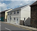
Recently-built semi-detached houses, Ferndale
Viewed across Duffryn Street in early August 2013. A Google Earth Street View taken in August 2012 shows the houses at an early stage of construction.
Image: © Jaggery
Taken: 8 Aug 2013
0.08 miles
10
Ordnance Survey Cut Mark
This OS cut mark can be found on the porch of St Dunstan's Church. It marks a point 237.772m above mean sea level.
Image: © Adrian Dust
Taken: 16 Jun 2017
0.08 miles