IMAGES TAKEN NEAR TO
Edward Street, FERNDALE, CF43 4DY
Introduction
This page details the photographs taken nearby to Edward Street, CF43 4DY by members of the Geograph project.
The Geograph project started in 2005 with the aim of publishing, organising and preserving representative images for every square kilometre of Great Britain, Ireland and the Isle of Man.

There are currently over 7.5m images from over14,400 individuals and you can help contribute to the project by visiting https://www.geograph.org.uk
Image Map
Images are licensed for reuse under creativecommons.org/licenses/by-sa/2.0
Notes
- Clicking on the map will re-center to the selected point.
- The higher the marker number, the further away the image location is from the centre of the postcode.
Image Listing (59 Images Found)
Images are licensed for reuse under creativecommons.org/licenses/by-sa/2.0
Image
Details
Distance
1
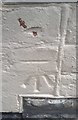
Ordnance Survey Cut Mark
This OS cut mark can be found on No92 Edward Street. It marks a point 321.835m above mean sea level.
Image: © Adrian Dust
Taken: 16 Jun 2017
0.01 miles
2
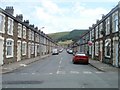
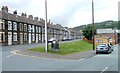
James Street, Maerdy
Viewed across Wood Street.
Image: © Jaggery
Taken: 11 May 2011
0.05 miles
3
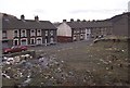
Edward Street, Maerdy
Maerdy has a distinctly careworn air in this 1999 view. The village was once known as a centre for radical politics, one of the few places in the UK where the Communist party had significant support, earning it the sobriquet 'Little Moscow'. However, Maerdy Colliery, on whose existence prosperity depended, closed in 1990, one of the last deep mines in South Wales. The houses on the extreme right of the picture have since been demolished.
Image: © Stephen McKay
Taken: Unknown
0.07 miles
4
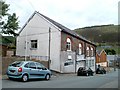
Maerdy Social Club
Located at the eastern end of Church Street.
Image: © Jaggery
Taken: 11 May 2011
0.07 miles
5
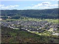
Maerdy
View of Maerdy from a path leading down from Mynydd y Ffaldau.
Image: © Alan Hughes
Taken: 4 May 2019
0.08 miles
6
North Terrace, Maerdy
On the left is a long row of houses on North Terrace. On the right, the orangey-brown building is the recently refurbished library. http://www.geograph.org.uk/photo/2411963
In the foreground, a roundel http://www.geograph.org.uk/photo/2412357 on a rock declares that Rhondda is the Gem of the Valleys.
Image: © Jaggery
Taken: 11 May 2011
0.09 miles
7
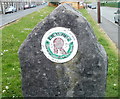
Rhondda - gem of the valleys, Maerdy
A rather faded roundel embedded in a rock declares that Rhondda is the gem of the valleys. Presumably there is little disagreement with that opinion here in Maerdy, at the top of the Rhondda Fach valley, though residents of other South Wales valleys may disagree!
The location is at the intersection of North Terrace (on the left) and Park Place. http://www.geograph.org.uk/photo/2412369
Image: © Jaggery
Taken: 11 May 2011
0.09 miles
8
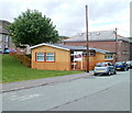
Maerdy public library
The Rhondda Cynon Taf Council public library is located on a triangle of land between Park Place and North Terrace, next door to the community centre. http://www.geograph.org.uk/photo/2411898
By 2009, the library had become shabby externally, and was in need of internal updating. With a £120,000 grant from CyMAL, the Welsh Assembly Government Capital Funding division, and £12,000 from the council, refurbishment and updating took place between November 2009 and January 2010. The result is an attractive exterior and modernised interior, with a new ICT suite.
Image: © Jaggery
Taken: 11 May 2011
0.09 miles
9
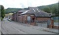
Maerdy Community Centre
Located in Park Place. The community centre opened here in 1994 in a converted former police station.
Image: © Jaggery
Taken: 11 May 2011
0.09 miles