1
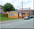
North Terrace, Maerdy
On the left is a long row of houses on North Terrace. On the right, the orangey-brown building is the recently refurbished library. http://www.geograph.org.uk/photo/2411963
In the foreground, a roundel http://www.geograph.org.uk/photo/2412357 on a rock declares that Rhondda is the Gem of the Valleys.
Image: © Jaggery
Taken: 11 May 2011
0.02 miles
2
Rhondda - gem of the valleys, Maerdy
A rather faded roundel embedded in a rock declares that Rhondda is the gem of the valleys. Presumably there is little disagreement with that opinion here in Maerdy, at the top of the Rhondda Fach valley, though residents of other South Wales valleys may disagree!
The location is at the intersection of North Terrace (on the left) and Park Place. http://www.geograph.org.uk/photo/2412369
Image: © Jaggery
Taken: 11 May 2011
0.02 miles
3
Maerdy public library
The Rhondda Cynon Taf Council public library is located on a triangle of land between Park Place and North Terrace, next door to the community centre. http://www.geograph.org.uk/photo/2411898
By 2009, the library had become shabby externally, and was in need of internal updating. With a £120,000 grant from CyMAL, the Welsh Assembly Government Capital Funding division, and £12,000 from the council, refurbishment and updating took place between November 2009 and January 2010. The result is an attractive exterior and modernised interior, with a new ICT suite.
Image: © Jaggery
Taken: 11 May 2011
0.02 miles
4
Maerdy Community Centre
Located in Park Place. The community centre opened here in 1994 in a converted former police station.
Image: © Jaggery
Taken: 11 May 2011
0.02 miles
5
Maerdy
View of Maerdy from a path leading down from Mynydd y Ffaldau.
Image: © Alan Hughes
Taken: 4 May 2019
0.03 miles
6
Maerdy Social Club
Located at the eastern end of Church Street.
Image: © Jaggery
Taken: 11 May 2011
0.05 miles
7
Western Welsh bus at North Terrace, Maerdy ? 1974
Classic Welsh valleys mining scenery. The distant bus was heading for the large mine at the head of the valley, although there had previously been a second pit at around its location, later occupied by the Avon rubber factory https://www.geograph.org.uk/photo/2411583 .
The bus is Western Welsh HR 4.69, a Leyland Atlantean with Northern Counties bodywork new in 1969 to Rhondda Transport. As part of the National Bus Company, Rhondda was absorbed by Western Welsh and joined with Red & White to become National Welsh, although the separate Western Welsh and Red & White fleetnames were retained for a few years.
This is one of a series of views featuring buses in the 60s, 70s, and 80s. http://www.geograph.org.uk/search.php?i=137652761
Image: © Alan Murray-Rust
Taken: 8 Mar 1975
0.05 miles
8
Ordnance Survey Cut Mark
This OS cut mark can be found on the west face of All Saints Church. It marks a point 295.537m above mean sea level.
Image: © Adrian Dust
Taken: 16 Jun 2017
0.06 miles
9
Mardy Colliery memorial, Maerdy
A coal truck on a plinth at the SW edge of Maerdy Park is a memorial http://www.geograph.org.uk/photo/2412383 to Mardy Colliery, which closed in 1990.
Image: © Jaggery
Taken: 11 May 2011
0.06 miles
10
Mardy Colliery memorial text, Maerdy
The text is on the plinth http://www.geograph.org.uk/photo/2412379 supporting a coal truck.
Image: © Jaggery
Taken: 11 May 2011
0.06 miles


